![]()
There are Himalayan treks that take you through the mountains, and there are treks that take you into them. The Kuari Pass trek is the second kind. Named after Lord Curzon — the British Viceroy of India (1899–1905) who explored this route during his tenure and was so moved by what he found that it became known as the Curzon Trail — the pass sits at approximately 3,815–3,900 metres (12,500–12,800 feet) in the Garhwal Himalayas of Uttarakhand, looking directly at the faces of Nanda Devi, Dronagiri, Kamet, Trishul, Hathi Ghoda, and Chaukhamba. On a clear day, it is one of the most spectacular panoramas accessible to a beginner Himalayan trekker. On any day, it is worth the climb.
Add the Pangarchulla peak extension — a summit push to approximately 4,550–4,600 metres (roughly 14,900–15,100 feet) — and the Kuari Pass trek transforms from a beginner-friendly ridge walk into one of the most rewarding summit experiences in the Garhwal. This guide covers both in full.
Kauri Pass Trek History: Lord Curzon and the Trail That Bears His Name
The Kuari Pass trek is one of the few Himalayan treks with a documented colonial-era history. Lord Curzon — Viceroy of India from 1899 to 1905 — explored this ridge route during his tenure, reportedly captivated by the views of the Nanda Devi massif from the pass. The route was subsequently referred to as the Curzon Trail, a name still used by many trekkers today.
The villages along the route — Gulling, Khullara, Gorson Bugyal — have been inhabited for centuries by communities whose lives have revolved around the high-altitude meadows (bugyals) that define this section of the Garhwal. The bugyal — high-altitude grassland that serves as summer pasture for shepherds — is the dominant landscape of the Kuari Pass trek, and the communities that maintain them are among the most interesting cultural encounters on any Himalayan trek.
How to Reach Joshimath?
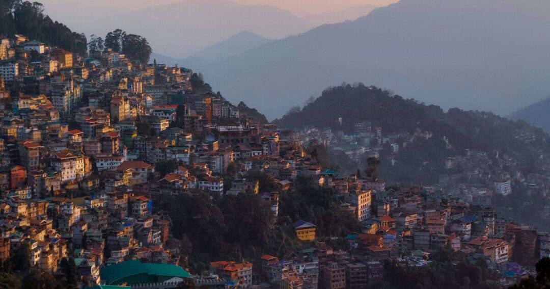
Joshimath is the gateway to the Kuari Pass trek — a small Himalayan town at approximately 1,875 metres in Chamoli district, Uttarakhand.
From Dehradun (~300 km | 9–10 hours):
- Road via Rishikesh → Devprayag → Rudraprayag → Chamoli → Joshimath
- Buses available from Dehradun ISBT; shared jeeps and private taxis also available
- The drive through the Alaknanda valley is spectacular — one of Uttarakhand’s finest road journeys
From Haridwar (~270 km | 8–9 hours):
- Similar route via Rishikesh
- Early morning buses from Haridwar connect to Joshimath
From Delhi (~500 km | 13–14 hours):
- Overnight buses from Delhi ISBT to Joshimath or Badrinath; change at Rishikesh or Haridwar
- By train to Haridwar (5–6 hours from Delhi), then bus/taxi to Joshimath
At Joshimath:
- Hotels, guesthouses, and gear shops available
- Last reliable ATM point before the trek; carry sufficient cash
- The trek typically begins from Dhak village (~15 km from Joshimath by road) or from Auli depending on the route variant
Also Read: Places to Visit in Uttarakhand: 12 Stunning Destinations for Every Traveller
Kuari Pass — Key Facts
| Detail | Info |
| Kuari Pass height | ~3,815–3,900 m (12,500–12,800 ft) |
| Pangarchulla peak height | ~4,550–4,600 m (~14,900–15,100 ft) |
| Base town | Joshimath, Chamoli district, Uttarakhand |
| Joshimath altitude | ~1,875 m (6,150 ft) |
| Kuari Pass trek distance | ~33–35 km round trip (Kuari Pass only) |
| Duration | 5–6 days (Kuari Pass); 6–7 days (with Pangarchulla) |
| Difficulty | Easy to Moderate (Kuari Pass); Moderate to Difficult (Pangarchulla extension) |
| Best season | March to June; September to November |
| Nearest railway station | Haridwar (~270 km from Joshimath) |
| Nearest airport | Jolly Grant Airport, Dehradun (~300 km) |
| Permits | Forest department permit required |
Kuari Pass Trek Distance & Route — Full Day-by-Day Itinerary
The standard Kuari Pass trek itinerary is 5–6 days from Joshimath. Adding the Pangarchulla summit push extends this to 6–7 days. All distances are approximate and vary slightly by route variant.
Day 1: Joshimath / Dhak Village to Gulling Camp
- Drive: Joshimath to Dhak village (~15 km, approximately 45 minutes)
- Trek distance: ~5–6 km
- Altitude gain: ~800 m
- Starting altitude: Dhak village ~2,000 m
- Ending altitude: Gulling ~2,800 m (9,186 ft)
- Trek time: Approximately 4–5 hours
The trek begins at Dhak village and climbs through oak and rhododendron forest. The first day is a sustained but manageable ascent through dense forest cover that shields the trail from direct sun. Gulling is a small forest clearing with a campsite and views beginning to open toward the distant peaks.
- The rhododendron forest on this section flowers brilliantly in April–May — one of the finest forest sections on any Garhwal trek
- The trail is well-marked; first-time trekkers will find the pace and terrain confidence-building
- Campsite: Gulling (~2,800 m)
Day 2: Gulling to Khullara Camp
- Trek distance: ~8 km
- Altitude gain: ~500 m
- Starting altitude: ~2,800 m
- Ending altitude: Khullara ~3,100 m (10,170 ft)
- Trek time: Approximately 3–4 hours
The second day continues through mixed forest before breaking into open meadow terrain as the trail approaches Khullara. The views expand significantly on this day — Hathi Ghoda Parbat and the surrounding peaks begin to dominate the skyline. Khullara camp sits on an open meadow ridge that offers the first truly panoramic views of the trek.
- Khullara is the base for both the Kuari Pass day and the Pangarchulla summit push — most trekkers spend two nights here
- The meadow at Khullara is particularly beautiful in spring (April–May) when wildflowers cover the ground
- Campsite: Khullara (~3,100 m) — also written as Khulara or Khulera in different sources
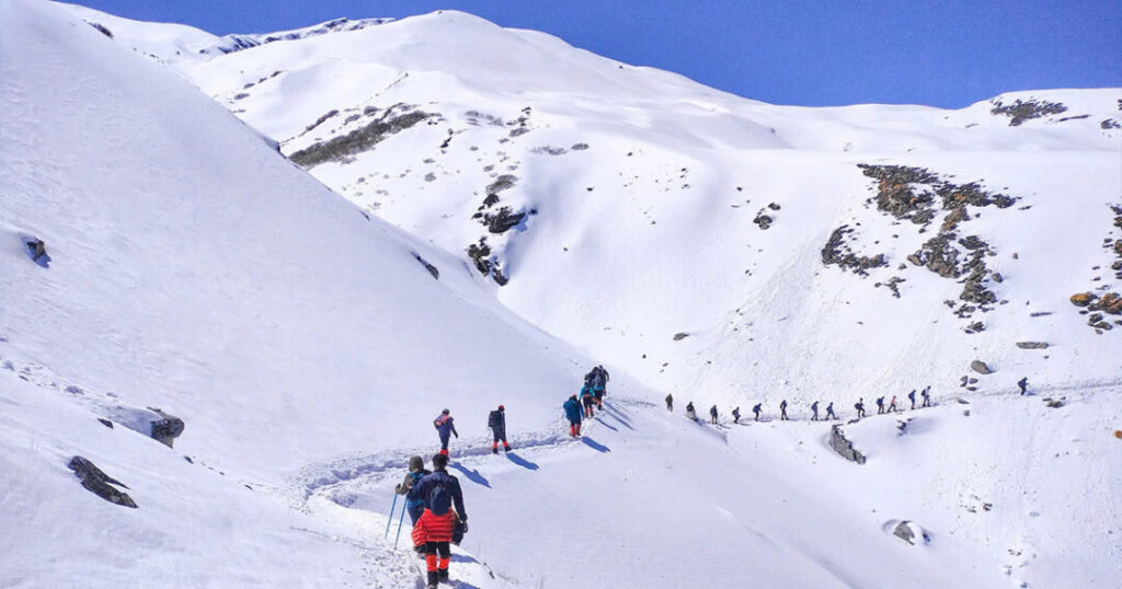
Day 3: Khullara to Kuari Pass and Return
- Trek distance: ~7 km one way (14 km round trip)
- Altitude gain: ~700–800 m
- Starting altitude: ~3,100 m
- Ending altitude (pass): ~3,815–3,900 m (12,500–12,800 ft)
- Trek time: Approximately 6–7 hours round trip
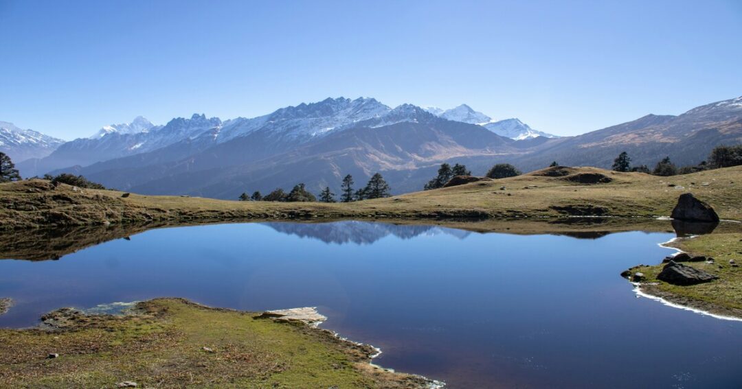
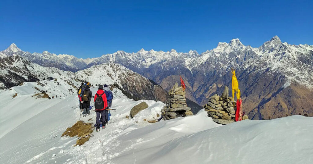
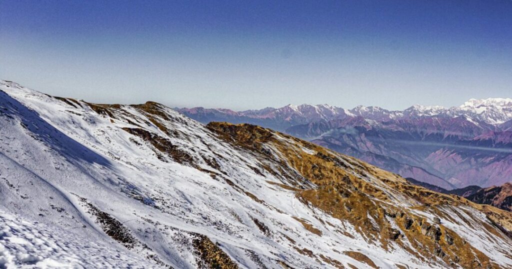
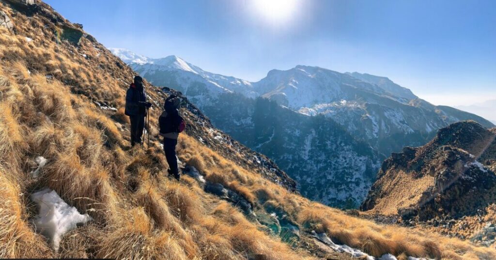
This is the main event of the Kuari Pass trek — the push from Khullara to the pass itself. The trail climbs steadily through increasingly open terrain, past the Tali campsite (an alternative camp at approximately 3,500 m), and up a final ridge to the pass. The Kuari Pass height delivers exactly what it promises: a near-360-degree panorama of the central Garhwal that includes Nanda Devi (India’s second-highest peak at 7,816 m), Dronagiri, Kamet, Trishul, Hathi Ghoda, and Chaukhamba.
- The view of Nanda Devi from Kuari Pass is one of the clearest and most frontal views of the peak accessible from any trekking trail in India
- The pass itself is a wide, exposed saddle — wind can be significant; carry a windproof layer
- In winter and spring, the section from Tali to the pass may require microspikes for safe crossing
- Return to Khullara after summit
Day 4 (Optional Extension): Khullara to Pangarchulla Peak Summit and Return
- Trek distance: ~13–14 km round trip | Altitude gain: ~1,450–1,500 m from Khullara
- Starting altitude: ~3,100 m | Summit altitude: ~4,550–4,600 m (~14,900–15,100 ft)
- Trek time: 10–12 hours; start time approximately 3–4 AM
The Pangarchulla peak trek extension is the most demanding day of the entire circuit — a pre-dawn start from Khullara, ascending steeply past the Kuari Pass and then continuing north on a narrowing ridge to the summit. The terrain becomes progressively more exposed and technically demanding above 4,000 metres. Microspikes and trekking poles are essential in winter; an ice axe may be required in heavy snow conditions.
The summit view from Pangarchulla is among the finest accessible from any non-technical Himalayan summit — a 180-degree panorama of central Garhwal peaks including Nanda Devi, Dronagiri, Changabang, Kamet, Abi Gamin, Mana, Hathi, Ghoda, Neelkanth, and the Chaukhamba massif.
- This day requires a 3–4 AM start — organise headlamps, warm layers, and a hot drink the night before
- The summit push is the most technically demanding section of the combined trek; do not attempt in poor visibility
- Return to Khullara camp; rest well before the descent the following day
Day 5: Khullara to Gorson Bugyal / Auli Descent
- Trek distance: ~8–10 km | Altitude loss: ~1,200 m
- Starting altitude: ~3,100 m | Ending altitude: Auli ~2,519 m or Joshimath ~1,875 m
The descent from Khullara offers a different routing option — continuing through Gorson Bugyal (a famous high-altitude meadow above Auli) before descending to Auli and then Joshimath by road. The Gorson Bugyal meadow is one of the finest grassland landscapes in the Garhwal and a fitting close to the trek.
- Gorson Bugyal to Auli is approximately 3 km of gentle descent; Auli to Joshimath is a short cable car ride or 4 km by road
- The cable car (ropeway) connecting Joshimath to Auli is one of the longest ropeways in Asia — a spectacular way to end the trek if it is operating (verify current status before planning)
- Return to Joshimath; drive to Haridwar/Dehradun/Delhi as required
Best Time for the Kuari Pass Trek?
| Season | Conditions | Recommended? |
| March to April | Snow on higher sections, rhododendron in bloom, fewer trekkers | ✅ Excellent — snow adds drama; rhododendron bloom is spectacular |
| May to June | Clear skies, wildflowers at Khullara and Gorson Bugyal, warm days | ✅ Best overall conditions for first-timers |
| July to August | Monsoon — trails slippery, visibility reduced, landslide risk | ❌ Not recommended |
| September to November | Post-monsoon clarity — arguably the finest mountain views of the year | ✅ Excellent — crystal clear skies, stable weather |
| December to February | Deep snow, very cold (-15°C or lower at night), requires winter gear | ⚠️ Experienced winter trekkers only |
Practical Tips — Gear, Fitness, AMS & Permits
Gear List
Essential:
- Footwear: Waterproof trekking boots with ankle support — mandatory
- Microspikes: Essential for winter and early spring (March–April) when the trail above 3,500 m may be icy
- Layers: Thermal base layer, fleece mid-layer, down jacket, waterproof shell — temperatures at Khullara camp drop to approximately 0°C to -5°C even in the warmer months
- Sleeping bag: Rated to -10°C for winter; -5°C for spring/autumn
- Trekking poles: Strongly recommended for the descent from Kuari Pass and the Pangarchulla push
- Headlamp: Essential for the pre-dawn Pangarchulla start; carry spare batteries
- Sun protection: SPF 50+ sunscreen, UV-rated sunglasses, brimmed hat — UV intensity at altitude is severe
For the Pangarchulla extension:
- An ice axe may be required in heavy snow conditions — check current conditions with the trekking operator before departure
Fitness and Difficulty
Kuari Pass only: Easy to moderate — suitable for fit beginners with no prior Himalayan trekking experience. The altitude gain is gradual and the terrain non-technical. The pass day (Day 3) is the most demanding, with approximately 700–800 m of ascent.
Kuari Pass + Pangarchulla: Moderate to difficult — the summit day is a 10–12 hour push with approximately 1,450 m of altitude gain from camp, pre-dawn start, and increasingly technical terrain above 4,000 m. Prior Himalayan trekking experience is strongly recommended.
Fitness benchmark: Be comfortable walking 10–12 km with a loaded daypack and 500–700 m of elevation gain before attempting Kuari Pass. For Pangarchulla, add cardiovascular conditioning for sustained effort over 10+ hours.
Altitude and AMS
The Kuari Pass height of approximately 3,815–3,900 m is significant enough to trigger AMS symptoms in susceptible trekkers — though the gradual altitude gain of the standard itinerary is well-designed for acclimatisation.
- Acclimatise at Joshimath (1,875 m) for at least one night before beginning
- Symptoms of AMS: headache, nausea, dizziness, loss of appetite, fatigue — descend immediately if symptoms worsen
- Pangarchulla (4,550–4,600 m) is at genuinely high altitude — AMS risk is significantly greater; never push through symptoms at this elevation
- Stay hydrated; avoid alcohol in the first 48 hours on trail
Permits
The Kuari Pass trek route passes through protected forest areas — a forest department permit is required.
- Permits are typically arranged through the trekking operator or at the forest department office in Joshimath
- Carry valid government-issued photo ID (Aadhaar or passport); foreign nationals should verify current inner-line permit requirements before travel
- The Pangarchulla area falls within the Nanda Devi Biosphere Reserve buffer zone — additional permits may be required; confirm with local authorities
Conclusion About Kuari Pass Trek
The Kuari Pass trek is one of the finest ridge walks in the Indian Himalayas — a route where the views are extraordinary, the terrain is manageable, and the extension to Pangarchulla turns the same mountains into a genuine summit experience.
Quick recap:
- Kuari Pass height: ~3,815–3,900 m (12,500–12,800 ft)
- Pangarchulla height: ~4,550–4,600 m (~14,900–15,100 ft)
- Kuari Pass trek distance: ~33–35 km round trip
- Duration: 5–6 days (Kuari Pass only); 6–7 days (with Pangarchulla)
- Difficulty: Easy to moderate (pass); Moderate to difficult (Pangarchulla)
- Best time: April–May for flowers; October for clarity
- Start point: Dhak village, near Joshimath, Chamoli district
- The trail: Named the Curzon Trail after Lord Curzon, Viceroy of India (1899–1905)
Download the Explurger app to log your Kuari Pass trek, discover what other trekkers say about current trail conditions, and plan your next Himalayan adventure.
The pass has been there since Lord Curzon looked at it in wonder during his time as Viceroy. It is still looking back. Go see it.
FAQs About the Kuari Pass trek
2. What is the Kuari Pass trek distance?
The total Kuari Pass trek distance is approximately 33–35 km round trip from the trailhead at Dhak village to the pass and back. The standard 5–6 day itinerary covers: Dhak to Gulling (~5–6 km), Gulling to Khullara (~8 km), Khullara to Kuari Pass and return (~14 km round trip), and descent via Gorson Bugyal to Auli (~8–10 km). Adding the Pangarchulla summit push adds approximately 13–14 km round trip to the total distance.
3. What is the Pangarchulla peak trek?
The Pangarchulla peak trek is the summit extension of the Kuari Pass circuit — a pre-dawn push from Khullara camp (3,100 m) to the Pangarchulla summit at approximately 4,550–4,600 metres (~14,900–15,100 feet). The summit day involves approximately 10–12 hours of trekking with a 3–4 AM start, steep terrain above 4,000 m, and potential snow and ice. The summit delivers a 180-degree panorama of central Garhwal peaks including Nanda Devi, Dronagiri, Changabang, Kamet, Neelkanth, and the Chaukhamba massif. Prior Himalayan trekking experience is recommended for the Pangarchulla extension.
4. What is the best time for the Kuari Pass trek?
The two best windows for the Kuari Pass trek are March to June (rhododendron bloom in April, wildflowers at Khullara in May–June, clear skies) and September to November (post-monsoon clarity with arguably the finest mountain views of the year). April and October are the single best months respectively — stable weather, manageable temperatures, and outstanding visibility. Avoid July and August (monsoon — slippery trails, poor visibility, landslide risk).
5. Is the Kuari Pass trek good for beginners?
Yes — the Kuari Pass trek (without the Pangarchulla extension) is consistently rated as one of the best introductory Himalayan treks. The altitude gain is gradual, the trail is well-marked, the campsites are established, and the summit view at the pass is genuinely extraordinary for a trek of this difficulty level. The Pangarchulla peak trek extension is significantly more demanding — a pre-dawn summit push with 10–12 hours of effort and high-altitude terrain above 4,500 m — and is better suited to trekkers with prior Himalayan experience.
6. What is the Lord Curzon connection to the Kuari Pass trek?
The Kuari Pass trek follows what is historically known as the Curzon Trail — named after Lord Curzon, the British Viceroy of India from 1899 to 1905, who explored this route during his tenure as Viceroy. Curzon was reportedly captivated by the views of the Nanda Devi massif from the pass, and the route was subsequently named in his honour. The trail is one of the few Himalayan trekking routes with a documented colonial-era exploration history, connecting the modern trekking experience to a journey made over a century ago.