![]()
Most travellers know about UNESCO World Heritage Sites. Far fewer know about UNESCO’s newest geoparks — a quietly growing network of some of the most geologically spectacular landscapes on Earth, spanning ancient volcanic fields, dramatic canyon systems, fossil-rich coastlines, and mountain formations that took hundreds of millions of years to build.
Every two years, UNESCO adds new sites to its Global Geoparks Network. Each one is a place where the ground beneath your feet tells a story stretching back to the very formation of our planet.
The problem is that these additions rarely make travel headlines. A new geopark designation doesn’t trend on social media the way a new national park might — but these landscapes are often just as spectacular, frequently less crowded, and almost always more educational.
This guide covers what a geopark actually is, which sites have been most recently designated, and why several of them deserve a serious place on your travel list.
What is a UNESCO Global Geopark?
Before we get to the new additions, a quick foundation — because “geopark” is still a term many travellers encounter for the first time.
A UNESCO Global Geopark is a unified geographic area where sites and landscapes of international geological significance are managed with a holistic concept of protection, education, and sustainable development.
In plain language: it’s a region with extraordinary geological features — ancient rock formations, volcanic landscapes, fossil beds, glacial valleys — that is actively protected, studied, and opened up for visitors in a responsible way.
[STAT: As of 2024, the UNESCO Global Geoparks Network includes over 195 geoparks across 48 countries — source: UNESCO Global Geoparks Network official records]
Geopark vs National Park — What’s the Difference?
This is one of the most common questions travellers ask, and the distinction is important:
| Feature | UNESCO Geopark | National Park |
| Primary focus | Geological heritage + education | Biodiversity + wildlife protection |
| Managed by | Local/regional authorities with UNESCO oversight | National government agencies |
| Tourism approach | Geotourism — science-led exploration | Nature tourism — recreation and conservation |
| Designation body | UNESCO | National government or IUCN |
| Overlap | Can include national parks within boundaries | Rarely includes geopark designation |
In practice, geoparks tend to offer a more interpretive, story-driven experience. You’re not just hiking through a beautiful landscape — you’re reading a geological narrative written in stone.
UNESCO Global Geoparks Network — How Designation Works?
To receive Global Geopark status, a site must:
- Contain geological heritage of international significance
- Have a clear management plan for conservation and sustainable tourism
- Demonstrate meaningful community involvement and local economic benefit
- Offer educational programmes for visitors and schools
- Commit to revalidation every four years (designations are not permanent)
The revalidation requirement is what makes this network unusually rigorous — a geopark that slips on conservation or visitor education can lose its status.
Also read: Hidden Gems: 10 Most Underrated UNESCO World Heritage Sites in INDIA Worth Visiting
UNESCO’s Newest Geoparks — The Latest Additions to the Global Network
Here are some of the most compelling recent and notable additions to the UNESCO Global Geoparks Network, each with travel context for curious visitors.
Aras Geopark — Iran
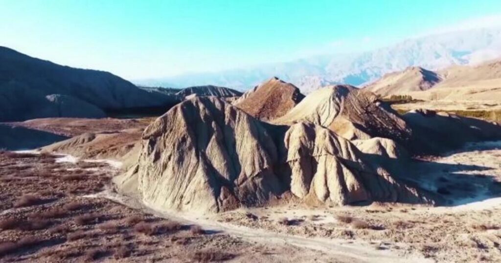
Location: Northwestern Iran, near the Aras River valley bordering Azerbaijan and Armenia. What makes it special: The Aras Geopark sits within one of the world’s most ancient geological zones. The area contains some of the oldest exposed rock formations in the Middle East, alongside rich fossil records, dramatic canyon landscapes, and evidence of significant tectonic activity over hundreds of millions of years.
Travel highlights:
- Spectacular canyon hiking through layered sedimentary rock
- Archaeological sites co-located within the geological terrain
- Rare opportunity to experience geological tourism in a region rarely featured on mainstream travel itineraries
Best time to visit: April–June and September–October (spring and autumn) for manageable temperatures and clear visibility in the canyons.
Nearest airport: Tabriz International Airport — approximately 100–130 km from the geopark’s main access points. International connections via Tehran.
Best for: Adventure travellers, geology enthusiasts, off-the-beaten-path explorers.
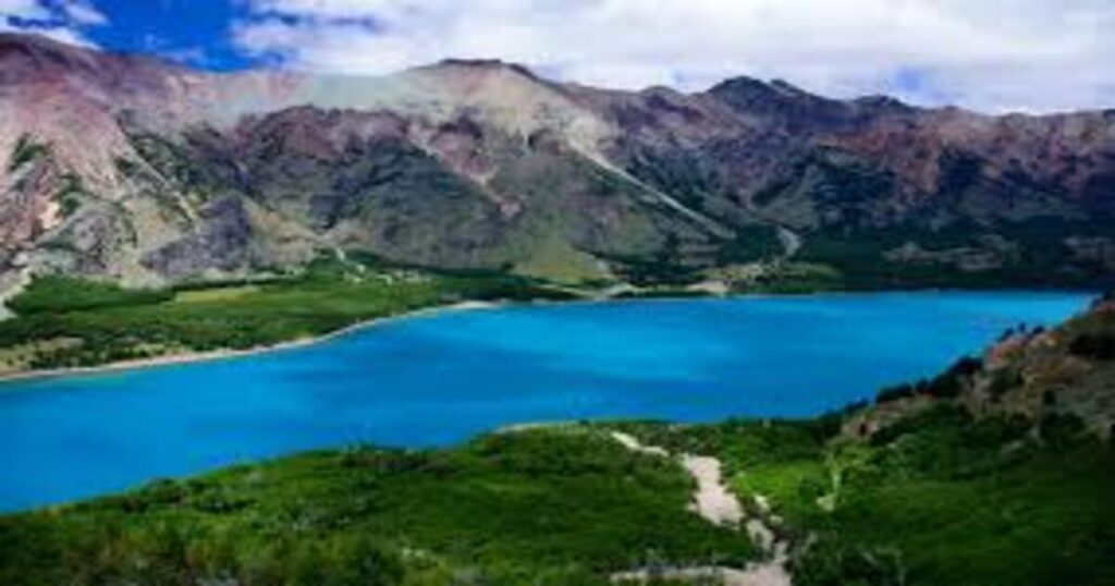
Aysén Geopark — Chile
Location: Patagonian region of southern Chile, Aysén Region. What makes it special: Aysén is one of the most geologically dramatic landscapes in South America. The geopark covers a vast area shaped by glaciers, volcanoes, and tectonic forces — featuring fjords, hanging glaciers, volcanic calderas, and ancient forests growing atop geological formations that predate the Andes themselves.
Travel highlights:
- Boat tours through fjords with active glacier views
- Hiking across lava fields and through ancient forest
- The Exploradores Glacier — one of the most accessible in Chilean Patagonia
- Extremely low visitor numbers compared to Torres del Paine — a genuine wilderness experience
Best time to visit: November–March (Southern Hemisphere summer) for the most accessible trails and stable weather.
Nearest airport: Balmaceda Airport (BBA), Coyhaique — the main gateway to the Aysén region, with connections from Santiago.
Best for: Serious hikers, nature photographers, travellers seeking off-grid Patagonian adventure.
Also read: Kenya Beyond Safaris: The 8 UNESCO Sites That Tell a Bigger Story
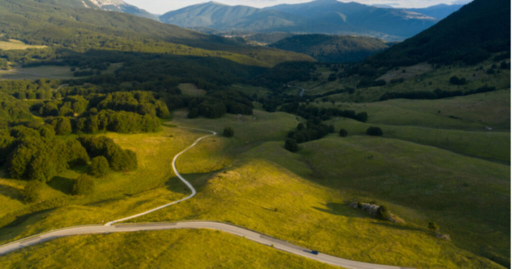
Majella Geopark — Italy
Location: Abruzzo region, central Italy — part of the Apennine mountain chain What makes it special: Majella is one of Europe’s most complete geological archives. The mountain massif contains an extraordinary record of marine sedimentation from when the central Mediterranean was a shallow tropical sea — visible today as dramatically layered limestone formations, fossil-rich outcrops, and karst cave systems.
Travel highlights:
- Hiking the Majella National Park trails (the geopark and national park overlap here)
- Exploring karst caves and fossil beds accessible on guided tours
- Visiting medieval hermitages built directly into cliff faces — a unique cultural layer on top of the geological one
- Truffle season (October–November): the surrounding Abruzzo region is one of Italy’s finest truffle territories
Best time to visit: May–June and September–October for comfortable hiking temperatures; January–February for snowshoeing in the high massif.
Nearest airport: Pescara Airport (PSR) — approximately 60 km from the geopark’s main entrance at Caramanico Terme. Rome Fiumicino (FCO) is also accessible, approximately 220 km away, with better international connections.
Nearest railway station: Pescara Centrale — regular regional trains connect to Sulmona (30 km from the park’s southern edge); local buses run from Sulmona into the park.
Best for: Hikers, history lovers, food-focused travellers, geology enthusiasts visiting Europe.
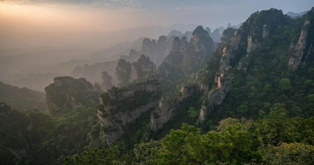
Zhangjiajie Wulingyuan — China (Extended Designation)
Location: Hunan Province, central China What makes it special: Zhangjiajie has long been one of China’s most iconic landscapes — the towering sandstone pillar formations that inspired the floating mountains of Avatar. Its geopark designation and subsequent extensions recognise the site not just for its visual drama but for the extraordinary geological processes behind it: quartz-sandstone pillar formation, deep canyon erosion, and karst dissolution working over 300 million years.
Travel highlights:
- The Tianmen Mountain cable car — the world’s longest passenger cable car
- Bailong Elevator — the world’s tallest outdoor lift, rising 330 metres up a cliff face
- Glass-bottomed sky bridges over canyon gaps
- Hiking trails that access areas far from the main tourist routes
Best time to visit: April–May and September–November for clear skies and moderate temperatures; avoid the Chinese Golden Week holidays (early October) for crowd management.
Nearest airport: Zhangjiajie Hehua International Airport — approximately 40 km from the geopark entrance. Direct flights from Beijing, Shanghai, Guangzhou, and Chengdu.
Best for: Landscape photographers, families, adventure seekers, travellers, combining with a broader China itinerary.
Tumuk Humak — Brazil
Location: Pará state, deep in the Amazon basin, near the Brazil-Suriname-French Guiana border. What makes it special: Tumuk Humak is one of the most remote and scientifically significant geoparks on Earth. The region contains some of the oldest exposed geological formations in South America — Precambrian crystalline basement rocks over 2 billion years old — sitting within one of the most biodiverse ecosystems on the planet. The geopark sits almost entirely within indigenous territories, making it a rare model of geological preservation meeting indigenous land rights.
Travel highlights:
- Exceptional biodiversity — the geological terrain supports unique micro-ecosystems
- Access is extremely limited and requires permits; most visitors are researchers or specialist ecotourism groups
- River journeys into one of the least-visited corners of the Amazon basin
Best time to visit: June–November (dry season) when river access is more manageable, and trails are passable.
Nearest airport: Belém Val de Cans International Airport (BEL) is the main hub — from there, small aircraft or river transport routes lead deeper into the region. Logistics require advanced planning through specialist tour operators.
Best for: Scientists, serious adventure travellers, conservation-minded explorers; not a casual visit.
Newly Designated Geoparks 2024 — Why This Year’s List is Special?
Each UNESCO designation cycle brings a new cohort of sites — but recent years have marked a meaningful shift in the network’s geographic reach.
Earlier cycles were heavily weighted toward Europe and East Asia. The newly designated geoparks 2024 and recent additions reflect a deliberate expansion:
- South America is gaining representation with sites like Aysén and Tumuk Humak
- The Middle East is appearing for the first time with sites like Aras (Iran)
- Africa continues to grow its presence with geoparks across Morocco, Tanzania, and South Africa
- Southeast Asia is emerging as a major contributor, with sites across Vietnam, Indonesia, and Malaysia
[STAT: The UNESCO Global Geoparks Network has grown by more than 40% in the past decade, with the most rapid expansion occurring in Asia and South America — source: UNESCO Global Geoparks Programme report]
This geographic diversification matters for travellers — it means that wherever you are in the world, a UNESCO geopark is increasingly likely to be within reach.
[QUOTE: on the expanding global reach of the UNESCO Geoparks Network — suggested source: Guy Martini, Chair of UNESCO Global Geoparks Network, or UNESCO Geoparks Programme official]
Geopark vs National Park — What Travellers Need to Know?
If you’re weighing up whether to include a geopark in your itinerary, the comparison with national parks is worth thinking through.
Geoparks often offer:
- Fewer crowds — they don’t yet have the brand recognition of national parks, which means more space for you
- More interpretive depth — guided geology walks, visitor centres with detailed rock sample displays, and educational programming that explains why the landscape looks the way it does
- Stronger local community connection — geopark designation requires local involvement, so you’re more likely to encounter locally owned accommodation, guides, and food
National parks often offer:
- Better infrastructure and marked trail systems
- More wildlife-focused programming
- Stronger legal protection for biodiversity
Many geoparks overlap with national parks — Majella is a good example — giving you both experiences in one destination.
Planning Your Geopark Visit — Practical Tips
How to Find UNESCO Geoparks Near You?
The UNESCO Global Geoparks Network maintains an official map and searchable database at geoparks.net and on the UNESCO website. You can filter by country, region, or geological feature type.
Most geoparks also have their own official websites with visitor information, trail maps, and guided tour bookings.
What to Expect on a Geopark Visit?
- Visitor centres at the entrance points — worth spending 30–60 minutes here before hiking; the geological context makes everything you see more meaningful
- Guided tours — available at most geoparks; geology guides are usually specialists who can read the landscape in a way general hiking guides cannot
- Signposted geological trails — look for numbered marker systems that correspond to a printed or downloadable trail guide
- Variable infrastructure — some geoparks are highly developed (Zhangjiajie); others (Tumuk Humak) are very remote with minimal facilities
Photography and Responsible Tourism in Geoparks
- Do not remove rocks, fossils, or geological samples — this is legally prohibited in most geoparks and undermines the scientific value of the site
- Stay on marked trails in areas with fragile geological formations
- Check drone regulations before flying — many geoparks have restrictions, especially those overlapping with national parks or indigenous territories
- The best light for geological photography is typically early morning or late afternoon, when low-angle sunlight picks out texture and layering in rock faces
Conclusion about UNESCO’s newest geoparks
UNESCO’s newest geoparks represent something genuinely rare in the modern travel landscape — places of international significance that most travellers haven’t discovered yet.
Here’s what to take away:
- Geoparks are geologically significant regions managed for conservation, education, and sustainable tourism
- The UNESCO Global Geoparks Network now spans 48 countries and is actively expanding into South America, the Middle East, and Africa
- Recent additions range from the remote Amazon wilderness of Tumuk Humak to the hiking paradise of Aysén in Chilean Patagonia to the fossils and hermitages of Majella in Italy
- Most geoparks are open to general visitors — you don’t need to be a geologist to enjoy them
- Plan visits around each site’s dry season and budget extra time for the visitor centre
Discover geoparks and extraordinary nature destinations worldwide — add Explurger to your travel toolkit and find real reviews from travellers who’ve been there.
The next time UNESCO announces a new designation cycle, you’ll know exactly what to look for — and why it matters.
FAQs About UNESCO’s newest geoparks
2: How many UNESCO Global Geoparks are there in 2024?
As of 2024, the UNESCO Global Geoparks Network includes over 195 designated geoparks across 48 countries. The network has grown significantly in recent years, with new additions announced every two years at the Global Geoparks Conference. Europe currently holds the largest number of sites, followed by East Asia, but recent designation cycles have expanded the network into South America, the Middle East, and sub-Saharan Africa.
3: What is the difference between a UNESCO Geopark and a UNESCO World Heritage Site?
A UNESCO World Heritage Site is designated for outstanding universal value — cultural or natural — and is typically a specific landmark or bounded area. A UNESCO Global Geopark is designated specifically for geological significance and covers broader regions that integrate conservation, education, and sustainable local development. A site can hold both designations simultaneously — for example, the Giant's Causeway in Northern Ireland is both. Geoparks are also subject to mandatory revalidation every four years, whereas World Heritage status is generally permanent.
4: Can tourists visit UNESCO Geoparks freely?
Most UNESCO Geoparks are fully open to the public, often free of charge or at low cost. They typically have visitor centres, guided trail programmes, and educational facilities. However, some geoparks — particularly those in remote regions or overlapping with indigenous territories, such as Tumuk Humak in Brazil — have restricted access that requires advance permits or specialist tour operators. It is always worth checking the specific geopark's official website for visitor regulations before planning a trip.
5: Which country has the most UNESCO Geoparks?
China currently leads the world in the number of UNESCO Global Geoparks, with [STAT: approximately 47 designated sites — source: UNESCO Global Geoparks Network]. Europe as a whole has the highest regional concentration, led by Spain, Italy, and Germany. The United Kingdom has several, including the Marble Arch Caves Geopark (Ireland/Northern Ireland) and the North Pennines Geopark in England.
6: Is visiting a geopark only for geology enthusiasts?
Not at all. While geology is the foundation of every geopark designation, the visitor experience is designed for general audiences — curious travellers, hikers, families, and photographers are all well served. Most geoparks offer activities that require no geological knowledge: scenic hiking, wildlife watching, cultural heritage tours, and photography. The geological layer simply adds depth and context to a landscape you'd likely find beautiful regardless. Think of it as a national park where the landscape comes with a story.