![]()
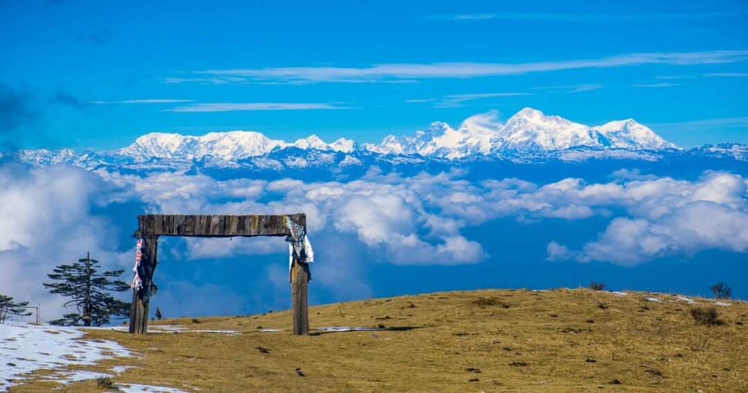
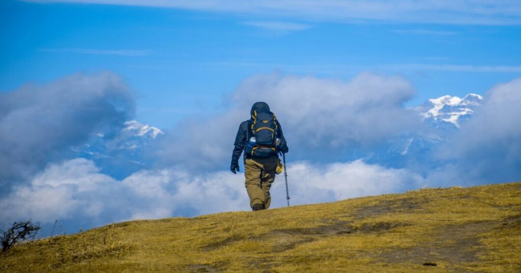
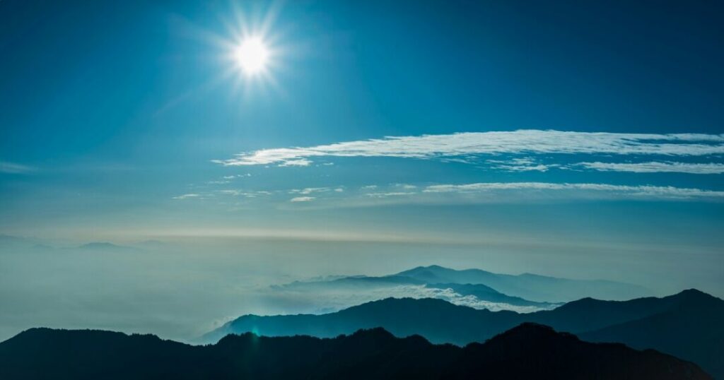
There is one thing that makes the Sandakphu trek genuinely unlike any other trek in India: from the summit on a clear morning, you can see four of the five highest mountains on earth simultaneously—Everest (8,849 m), Kangchenjunga (8,586 m), Lhotse (8,516 m), and Makalu (8,485 m). No other trekking summit in the country offers this. At 3,636 meters (11,929 feet), Sandakphu is the highest point in West Bengal and the highest peak on the Singalila Ridge—a north-south mountain ridge running along the West Bengal-Nepal border through the Singalila National Park. Extend the trek to Phalut (3,600 m / 11,800 ft) — the second-highest peak in West Bengal, 21 km further along the ridge — and the Sandakphu Phalut trek becomes one of the finest ridge traverses in the Eastern Himalayas.
This guide covers everything: the key facts, the full day-by-day itinerary, the Phalut extension, the best time to go, and the practical details that will make or break your trip.
Sandakphu Trek: 2026 Key Facts Every Trekker Should Know
| Detail | Information |
|---|---|
| Height of Sandakphu | 3,636 m (11,929 ft) |
| Height of Phalut | 3,600 m (11,800 ft) |
| Location | Singalila Ridge, West Bengal–Nepal Border |
| Trek Starting Point | Manebhanjang (2,134 m / 7,000 ft) |
| National Park | Singalila National Park |
| Sandakphu Trek Distance | Approx. 32 km one way |
| Sandakphu–Phalut Trek Distance | Approx. 53 km one way |
| Trek Duration | 4–5 days (Sandakphu), 6–7 days (with Phalut) |
| Difficulty Level | Moderate |
| Best Time for Sandakphu Trek | March–May, October–November |
| Nearest City | Darjeeling (26 km) |
| Distance from Siliguri | About 75 km to Manebhanjang |
The Sandakphu Trek is the highest trekking route in West Bengal, taking adventurers to an elevation of 3,636 meters (11,929 feet) along the scenic Singalila Ridge. Known for its breathtaking views of four of the world’s highest peaks—Everest, Kanchenjunga, Lhotse, and Makalu—the trek offers a perfect blend of mountain landscapes, rhododendron forests, and Himalayan culture. With moderate difficulty and well-defined trails, the Sandakphu Trek remains one of the most rewarding trekking experiences in Eastern India.
Also read: Kuari Pass Trek: The Complete Guide to the Curzon Trail & Pangarchulla Summit
What Makes Sandakphu Trek Special — The Sleeping Buddha and Four Summits
The Sandakphu summit delivers two experiences found nowhere else in Indian trekking:
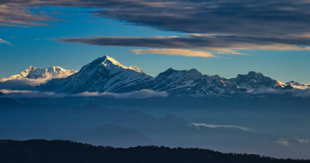
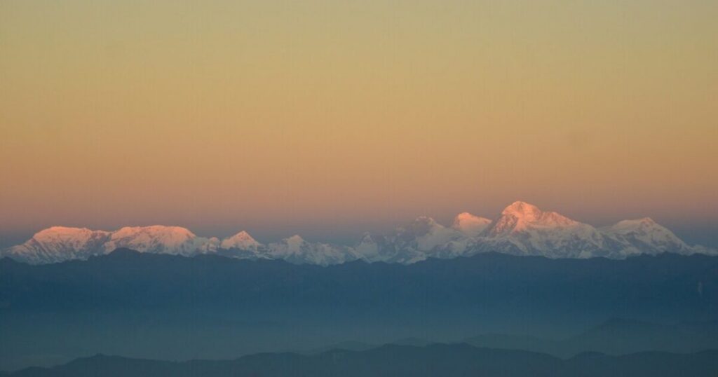
The four-summit view: On a clear dawn, Sandakphu offers a simultaneous view of Everest (the world’s highest), Kangchenjunga (third highest), Lhotse (fourth highest), and Makalu (fifth highest). Sandakphu is the only place in India where four of the world’s five highest peaks are visible at once.
The Sleeping Buddha (Shupta Buddha): The Kangchenjunga massif—when viewed from Sandakphu—takes the form of a reclining human figure against the horizon. The peaks of Kangchenjunga, Kabru, and Rathong align to create the silhouette of a sleeping figure, with the summit representing the head and the ridgelines forming the chest and feet. This formation, known as the Sleeping Buddha, is one of the most photographed mountain profiles in the Himalayas.
The name “Sandakphu” derives from the poisonous plant aconite (Aconitum species) that grows prolifically on the hilltop—the name translates approximately as “Height of Poisonous Plant” in the local Limbu language.
The national park: The entire Sandakphu trek route passes through Singalila National Park, established in 1986, home to red pandas, Himalayan black bears, barking deer, clouded leopards, and over 300 species of birds. The rhododendron forests that line the ridge are among the finest in the eastern Himalayas.
How to Reach Manebhanjang (Trek Base)?
Manebhanjang is the starting point of the Sandakphu trek—a small border town at approximately 2,134 meters, about 26 km from Darjeeling.
From Darjeeling (~26 km | 1 hour):
- By shared jeep or private cab — the most common approach; frequent jeeps from Darjeeling’s Chowk Bazaar to Manebhanjang throughout the day
- The road is scenic; the last section climbs steeply into the ridge
From Siliguri (~75 km | 2.5–3 hours):
- By jeep or cab via Darjeeling or the direct Mirik route; NJP (New Jalpaiguri) railway station is the primary rail access point for the entire region
From Kolkata:
- Overnight train to NJP or Darjeeling (narrow-gauge toy train to Darjeeling); then jeep to Manebhanjang—a full day’s travel
Permits: A permit for Singalila National Park is mandatory. Entry permit (Indian and foreign nationals) issued at the Manebhanjang checkpoint. Foreign nationals require an additional inner-line permit (restricted area permit)—apply through the Darjeeling District Magistrate’s office or through a registered trekking operator. Carry a photo ID.
Also read: Kudremukh Trek: Everything You Need to Know Before Conquering Karnataka’s Iconic Peak
Sandakphu Trek Route — Full Day-by-Day Itinerary
Standard 4-Day Sandakphu Trek Itinerary
Day 1: Manebhanjang to Tumling
- Trek distance: ~11 km | Altitude gain: ~750 m
- Starting altitude: Manebhanjang ~2,134 m | Ending altitude: Tumling ~2,970 m
- Trek time: Approximately 5–6 hours
The trek begins at Manebhanjang and follows the Indo-Nepal border ridge—a wide jeep track through rhododendron and oak forest. The trail alternates between Indian and Nepali territory as the ridge meanders; this is normal, and no permits are required for the Nepali sections of the trail. The first major viewpoint appears at Chitre (~2,600 m), where Kangchenjunga becomes visible on a clear day. The trail continues to Tumling, a small settlement straddling the border with guesthouses on both sides.
- The wide jeep track means some sections of the Sandakphu trek can also be completed by 4WD Land Rovers—a popular option for those who want to reduce walking distance
- Tumling has basic but comfortable trekkers’ huts and homestays; the sunset view of Kangchenjunga from Tumling is extraordinary
- Camp/Night: Tumling (~2,970 m)
Day 2: Tumling to Kalipokhri (via Gairibans and Kaiyakatta)
- Trek distance: ~14 km | Altitude gain: ~580 m
- Starting altitude: Tumling ~2,970 m | Ending altitude: Kalipokhri ~3,170 m
- Trek time: Approximately 6–7 hours
The longest day of the standard itinerary—the trail passes through the hamlet of Gairibans (~2,621 m), where rhododendron forests become denser and the trail narrows from jeep track to proper footpath. At Kaiyakatta (~3,000 m), the trail enters the high ridge proper—the vegetation becomes more alpine, and the views to Nepal open significantly. Kalipokhri (“black lake” in Nepali) is a small Nepali village at approximately 3,170 m, named for a small dark lake surrounded by prayer flags and pine trees—one of the most atmospheric overnight stops on the entire route.
- The Kalipokhri lake is a significant local landmark—the dark water surrounded by prayer flags makes it one of the most photographed spots on the Sandakphu trekking route
- The village has guesthouses and basic restaurants; the evening cold at 3,170 m requires warm layering
- Camp/Night: Kalipokhri (~3,170 m)
Day 3: Kalipokhri to Sandakphu Summit
- Trek distance: ~7 km | Altitude gain: ~466 m
- Starting altitude: Kalipokhri ~3,170 m | Ending altitude: Sandakphu ~3,636 m (11,929 ft)
- Trek time: Approximately 3–4 hours
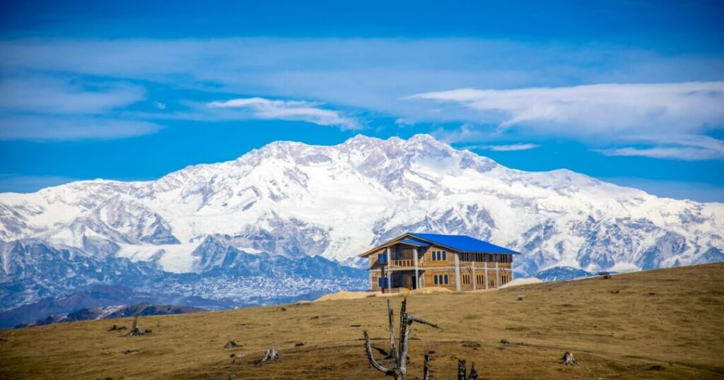
The final push to the Sandakphu peak is a relatively short day after the long Day 2, allowing for a late-morning arrival at the summit and time to rest before the crucial pre-dawn wake-up. The trail from Kalipokhri climbs steadily through the last rhododendron sections and emerges onto the broad open ridge below Sandakphu. The summit itself is a broad area with a trekkers’ hut, a small Indian Army outpost, and the extraordinary 360-degree view.
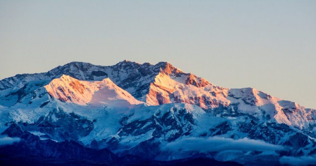
The Sandakphu summit view:
- Everest (8,849 m) — visible to the northwest, the distinctive pyramidal summit above the horizon
- Kangchenjunga (8,586 m)—dominant to the north, the Sleeping Buddha profile unmistakable
- Lhotse (8,516 m) — adjacent to Everest, the fourth highest in the world
- Makalu (8,485 m) — to the right of Everest, fifth highest in the world
- The pre-dawn alarm is non-negotiable—set for 4:30–5:00 AM for the best light; the mountains are clearest before clouds build after 8–9 AM
- The summit has basic accommodation in trekkers’ huts—book in advance for peak season (March–May, October–November)
- Wind at the summit can be significant; carry a windproof outer layer regardless of lower-altitude temperatures
- Camp/Night: Sandakphu (~3,636 m)
Day 4: Sandakphu to Manebhanjang (Descent)
- Trek distance: ~32 km (descent via same route) | Duration: Full day
- Alternatively: Descend via Rimbik (~2,290 m)—a different descent route through Srikhola and Rimbik village, approximately 22 km, allowing a jeep pickup from Rimbik to Darjeeling
The standard descent follows the ascent route back to Manebhanjang—a long but straightforward day that most fit trekkers complete in 7–8 hours. The Rimbik descent is preferred by many, as it offers different scenery and ends with a road connection.
Also read: Nag Tibba Trek: The Complete Guide to the Serpent’s Peak Weekend Trek
Sandakphu Phalut Trek — The Ridge Extension
What Is the Phalut Extension?
The Sandakphu and Phalut trek extends the standard Sandakphu route by continuing south along the Singalila Ridge from Sandakphu to Phalut (3,600 m / 11,800 ft) — the second-highest peak in West Bengal — and then descending to Gorkhey or Rimbik. This adds approximately 2 days to the standard itinerary and transforms the trek from an out-and-back to a full ridge traverse.
Why Phalut matters: While Sandakphu offers the most famous four-summit view, Phalut offers arguably the closest and most frontal view of Kangchenjunga from any trekking point in India — the mountain fills the northern horizon from the Phalut summit in a way that is different from and complementary to the Sandakphu perspective. The traverse between the two summits follows one of the finest ridge walks in the Eastern Himalayas—almost entirely above 3,000 m, through high-altitude meadows and the last rhododendron forest sections.
Day 4 (Phalut Extension): Sandakphu to Sabarkum
- Trek distance: ~10 km | Altitude: Stays above 3,200 m throughout
- Ending altitude: Sabarkum ~3,543 m
- Trek time: Approximately 4–5 hours
The trail from Sandakphu toward Phalut follows the ridge south through open high-altitude terrain — largely above the treeline, with views into Nepal on the west and the Darjeeling hills on the east. Sabarkum (the third-highest peak in West Bengal at 3,543 m) is the overnight stop—a basic trekkers’ hut in a remote but extraordinarily scenic location.
- Very few trekkers extend to Phalut; the trail from Sandakphu to Phalut is significantly less trafficked than the Manebhanjang approach
- The trail can be difficult to follow in low visibility; a local guide is strongly recommended
- Camp/Night: Sabarkum (~3,543 m)
Day 5 (Phalut Extension): Sabarkum to Phalut Summit and Descent to Gorkhey
- Trek distance: ~11 km to Phalut + ~12 km descent to Gorkhey
- Phalut summit altitude: 3,600 m (11,800 ft)
- Ending altitude: Gorkhey ~2,380 m
- Trek time: Approximately 8–9 hours total
The Phalut summit push from Sabarkum is approximately 4 km—a short, clear ascent to the summit with its own extraordinary view. After the summit, the descent drops steeply off the ridge through dense rhododendron and mixed forest to Gorkhey, a settlement at approximately 2,380 m on the Sirikhola stream, with basic homestays and guesthouses.
From Gorkhey, most trekkers continue to Rimbik (approximately 5 km from Gorkhey) for jeep connections to Darjeeling.
What is the Best Time for the Sandakphu Trek?
| Season | Conditions | Recommended? |
| March to May (Spring) | Rhododendrons in full bloom (March–April); clear mornings; moderate temperatures; trail at its most beautiful | ✅ Best for forest scenery and rhododendrons |
| June to September (Monsoon) | Heavy rainfall; clouds reduce summit views; trails slippery, and leeches | ❌ Not recommended for summit views |
| October to November (Autumn) | Post-monsoon clarity; best mountain visibility of the year; stable weather | ✅ Best for mountain views |
| December to February (Winter) | Heavy snow; very cold (-10°C or below at summit); extraordinary winter landscape | ⚠️ Experienced winter trekkers only; carry full winter gear |
The two peak windows: March–April for the rhododendron forest experience (the entire ridge turns red and pink); October–November for the clearest summit views and the finest Everest-Kangchenjunga panorama.
Also read: Rudranath Trek: The Complete Guide to the Most Remote Panch Kedar
Practical Tips — Gear, Fitness & Permits
Gear List
- Footwear: Waterproof trekking boots — mandatory on the ridge
- Layers: Down jacket, fleece, thermal base layer, waterproof shell — summit temperatures drop significantly below valley temperatures
- Sleeping bag: -5°C rated for spring/autumn; -10°C or below for winter
- Trekking poles: Strongly recommended — particularly for the descent
- Sunscreen and UV sunglasses: UV intensity on the open ridge is severe
- Headlamp: For the pre-dawn summit push
Fitness
The Sandakphu trek is rated moderate — suitable for reasonably fit beginners with no prior Himalayan experience. The daily distances are manageable (7–14 km per day), the altitude gain is gradual, and accommodation is available in guesthouses along the route. The Phalut extension adds difficulty primarily through additional distance rather than technical terrain.
Permits
- Singalila National Park permit: Mandatory; issued at Manebhanjang gate
- Foreign nationals: Additional Restricted Area Permit required—obtain it from Darjeeling District Magistrate’s office or through a registered operator
- Phalut extension: No additional permits required beyond the National Park entry
Conclusion about Sandakphu Trek
The Sandakphu trek is the Eastern Himalaya’s finest gift to trekkers who want a genuine summit experience without technical climbing—and the Sandakphu Phalut trek extends that gift into one of the finest ridge traverses in the region.
Quick recap:
- Height of Sandakphu: 3,636 m (11,929 ft) — highest peak in West Bengal
- Phalut height: 3,600 m (11,800 ft)—second highest in West Bengal
- Trek base: Manebhanjang (~2,134 m), 26 km from Darjeeling
- Sandakphu trek route: Manebhanjang → Tumling → Kalipokhri → Sandakphu (~32 km one way, 4 days)
- Sandakphu and Phalut trek: Continues to Sabarkum → Phalut → Gorkhey → Rimbik (~53 km total, 6–7 days)
- The view: Everest, Kangchenjunga, Lhotse, Makalu — four of the world’s five highest peaks simultaneously
- Best time: March–April (rhododendrons); October–November (clearest views)
- Difficulty: Moderate — suitable for fit beginners
Download the Explurger Social Travel App to log your Sandakphu trek, discover what other trekkers recommend for current trail conditions, and plan your complete Eastern Himalaya adventure.
The Sleeping Buddha is already on the horizon. The rhododendrons are already in bloom. Sandakphu is waiting.
FAQs About Sandakphu Trek
2. What is the Sandakphu Phalut trek?
The Sandakphu Phalut trek is the full ridge traverse of the Singalila Ridge—continuing from Sandakphu (3,636 m) south along the ridge to Phalut (3,600 m / 11,800 ft), the second-highest peak in West Bengal. The Sandakphu and Phalut trek adds approximately 2 days to the standard Sandakphu itinerary, covering approximately 21 additional km along the high ridge via Sabarkum (3,543 m) and descending to Gorkhey and Rimbik. Phalut offers arguably the closest frontal view of Kangchenjunga from any trekking point in India.
3. What is the Sandakphu trek route?
The standard Sandakphu trek route starts at Manebhanjang (~2,134 m, 26 km from Darjeeling) and follows the Singalila Ridge north: Manebhanjang → Tumling (~2,970 m, Day 1, ~11 km) → Kalipokhri (~3,170 m, Day 2, ~14 km) → Sandakphu summit (~3,636 m, Day 3, ~7 km). Descent is via the same route to Manebhanjang or via Rimbik (~22 km different route). The Sandakphu Phalut trekking extension continues: Sandakphu → Sabarkum (~3,543 m) → Phalut (~3,600 m) → Gorkhey → Rimbik.
4. What mountains can you see from Sandakphu?
From the Sandakphu peak on a clear morning, you can see four of the world's five highest mountains simultaneously: Everest (8,849 m—world's highest), Kangchenjunga (8,586 m—third highest), Lhotse (8,516 m—fourth highest), and Makalu (8,485 m—fifth highest). Sandakphu is the only summit in India where this four-peak view is possible. The Kangchenjunga massif also forms the famous "Sleeping Buddha" profile from this vantage point.
5. What is the best time for the Sandakphu trek?
The Sandakphu trekking season has two peak windows. March to April is best for the rhododendron bloom—the entire Singalila Ridge turns red and pink, and the forest sections are at their most beautiful. October to November is best for mountain visibility—post-monsoon clarity delivers the clearest views of Everest, Kangchenjunga, Lhotse, and Makalu. Avoid June to September (monsoon—heavy rain, poor summit visibility, leeches). Winter (December–February) is possible for experienced trekkers but requires full winter gear, and temperatures can drop to -10°C or below at the summit.
6. Is the Sandakphu trek good for beginners?
Yes, the Sandakphu trek is rated moderate and is one of the most accessible Himalayan summit experiences in India. The trail is well-established with accommodation in guesthouses at each campsite (no tent required unless preferred), the altitude gain is gradual over 3–4 days, and the summit altitude of 3,636 m is manageable without prior acclimatization. The Sandakphu Phalut trek extension is more demanding due to additional distance but involves no technical terrain. A reasonable fitness level — comfortable walking 10–14 km per day — is sufficient for the standard Sandakphu itinerary.