![]()
The Rudranath Trek takes you to one of the most remote and spiritually significant shrines in the Garhwal Himalayas. Of the five sacred Shiva temples that make up the Panch Kedar pilgrimage, Rudranath is the one most people have never heard of—and the one those who have trekked it never forget. There are no roads leading to the temple. No cable cars, no mule shortcuts, and no chai stalls every kilometer. Just you, the mountains, dense rhododendron forests, high-altitude meadows (bugyals), glacial streams, and one of the most remote natural rock shrines in India—where Lord Shiva’s face (mukha) is worshipped in the form of Neelkantha Mahadev.
At approximately 3,559–3,600 meters (11,677–11,800 feet), Rudranath is consistently cited as the toughest and most rewarding of the Panch Kedar treks. Different pilgrimage traditions place it as either the 3rd or 4th Kedar in the sequence; what is universally agreed is that it is the most remote and demanding of the five. This guide covers the full route from both Sagar and Mandal, the Tungnath traverse, and everything you need to prepare.
Rudranath Trek: Highlights, Temple Details & Essential Trek Information
| Detail | Info |
|---|---|
| Temple Altitude | ~3,559–3,600 m (11,677–11,800 ft) |
| Location | Chamoli District, Uttarakhand |
| Deity | Lord Shiva (Neelkantha Mahadev) |
| Panch Kedar Order | 3rd or 4th Kedar |
| Base Village | Sagar (~2,000 m) / Mandal (~1,500 m) |
| Trek Distance | 19–22 km (Sagar) / 24 km (Mandal) |
| Duration | 4–5 days (Sagar) / 5–6 days (Mandal) |
| Difficulty | Difficult |
| Best Season | May–June & September–November |
| Nearest City | Gopeshwar (~3 km from Sagar) |
| From Rishikesh | ~241 km / 8–9 hours by road |
The Rudranath Trek is one of the most spiritually rewarding and scenically magnificent treks in the Garhwal Himalayas. Nestled in the Chamoli district of Uttarakhand, it leads pilgrims and trekkers to the sacred shrine of Lord Shiva at an altitude of over 3,500 m. Whether you choose the Sagar or Mandal route, this trek offers a perfect blend of devotion, adventure, and breathtaking Himalayan landscapes — making it an unmissable experience for every serious trekker and Shiva devotee.
The Mythology: Panch Kedar and Rudranath’s Place in It

The Panch Kedar pilgrimage has its roots in the Mahabharata. After the devastating Kurukshetra war, the Pandavas — guilt-ridden for killing their own kin — sought Lord Shiva’s absolution. Shiva, wishing to avoid them, disguised himself as a bull (Nandi) and hid among cattle in Kedar. Bhima spotted the bull and grabbed its tail; Shiva began to sink into the earth. Different body parts appeared at five different locations in the Garhwal Himalayas—each becoming a sacred site:
- Kedarnath (3,583 m)—the hump (prushtha) of the bull
- Tungnath (3,680 m) — the arms
- Rudranath (~3,559–3,600 m)—the face (mukha)—3rd or 4th in the pilgrimage sequence depending on the tradition followed
- Madhyamaheshwar (3,490 m) — the navel and stomach
- Kalpeshwar (2,200 m)—the hair (jata)
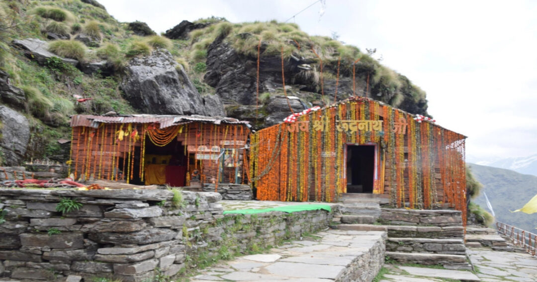
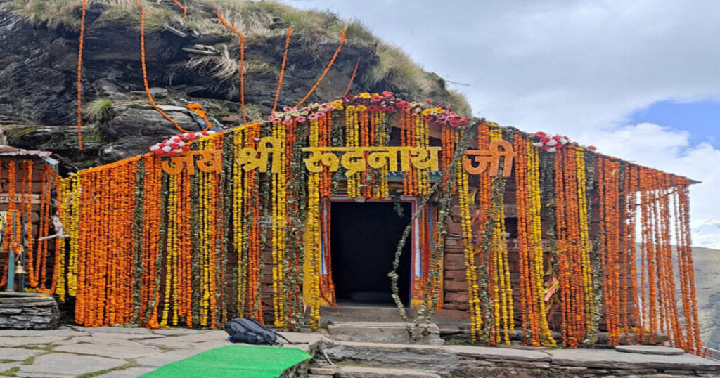
At Rudranath, it is Shiva’s face that is worshipped—an open-sky natural rock formation rather than an enclosed temple building. There is no stone roof over the main deity; the face of Shiva is a natural rock shaped by millennia, worshipped in the open under the Himalayan sky. This is what gives Rudranath its distinct character among the five Kedars—the most primal, the most elemental, and the most remote.
The word “Rudranath” means “Lord of Rudra”—Rudra being one of Shiva’s most fierce and ancient forms, associated with storms, wilderness, and destruction and renewal.
Also read: Devkund Waterfall Trek: The Complete Guide to Maharashtra’s Secret Waterfall
How Do You Reach the Rudranath Trek Trailhead?
Sagar Village (~3 km from Gopeshwar, Chamoli district):
From Rishikesh (~241 km | 8–9 hours):
- Road: Rishikesh → Devprayag → Rudraprayag → Chamoli → Gopeshwar → Sagar
- Buses from Rishikesh to Gopeshwar; shared jeeps and taxis from Gopeshwar to Sagar
- Most trekkers depart Rishikesh or Haridwar early in the morning for a late afternoon arrival at Sagar
From Haridwar (~255 km | 9–10 hours):
- Similar route via Rishikesh and Devprayag
From Delhi (~490 km | 12–13 hours):
- Overnight bus to Rishikesh or Haridwar, then continue to Sagar, or direct cab
For the Mandal route:
- Mandal village is approximately 16 km from Gopeshwar and accessible by road
Also read: Kudremukh Trek: Everything You Need to Know Before Conquering Karnataka’s Iconic Peak
Rudranath Trek Route 1 — Sagar Village Route (Main Route)
This is the most commonly trekked and best-documented Rudranath trek route—the standard approach for pilgrims and trekkers arriving from Gopeshwar.
Day 1: Rishikesh/Haridwar to Sagar Village
- Mode: Road (~241–255 km, 8–10 hours)
- Ending altitude: Sagar ~2,000 m
- Arrive at Sagar and register at the forest department checkpost (registration is required)
- Basic guesthouses and dharamshalas available in Sagar; some pilgrims camp near the trailhead
- This is the last point with reliable road access; stock up on supplies for the trail
Day 2: Sagar to Panar (Punar)
- Trek distance: ~8–9 km
- Altitude gain: ~900–1,000 m
- Starting altitude: Sagar ~2,000 m
- Ending altitude: Panar ~2,900–3,000 m
- Trek time: Approximately 5–6 hours
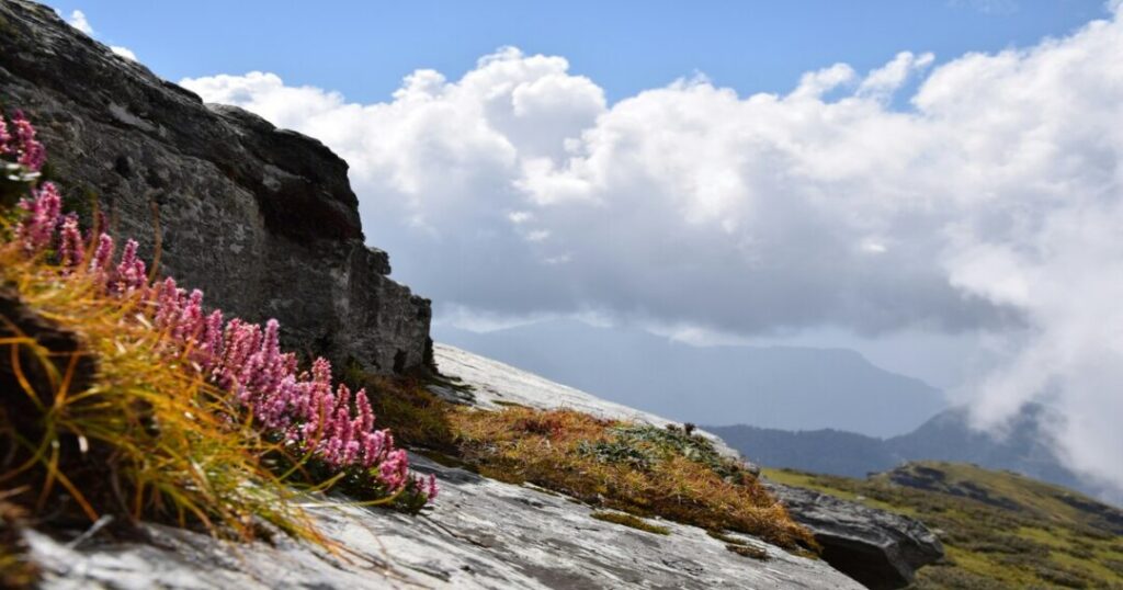
The trail begins from Sagar village and climbs steadily through dense oak and rhododendron forest—in May, the rhododendrons are in full flower and the forest is vivid red and pink. The trail is well-marked with painted stones and direction boards at key junctions. After crossing several stream beds and entering progressively denser forest, the trail reaches Panar—an open meadow campsite with a small dhaba (seasonal) and clean water from a nearby stream.
- The forest section on this day is the finest and most atmospheric of the entire trek
- Bring sufficient water from Sagar; the first reliable water source en route is approximately 4 km from the village
- Camp: Panar (~2,900–3,000 m)
Day 3: Panar to Pitu Bugyal
- Trek distance: ~6–7 km
- Altitude gain: ~500–600 m
- Starting altitude: ~2,900–3,000 m
- Ending altitude: Pitu Bugyal ~3,450–3,500 m
- Trek time: Approximately 4–5 hours
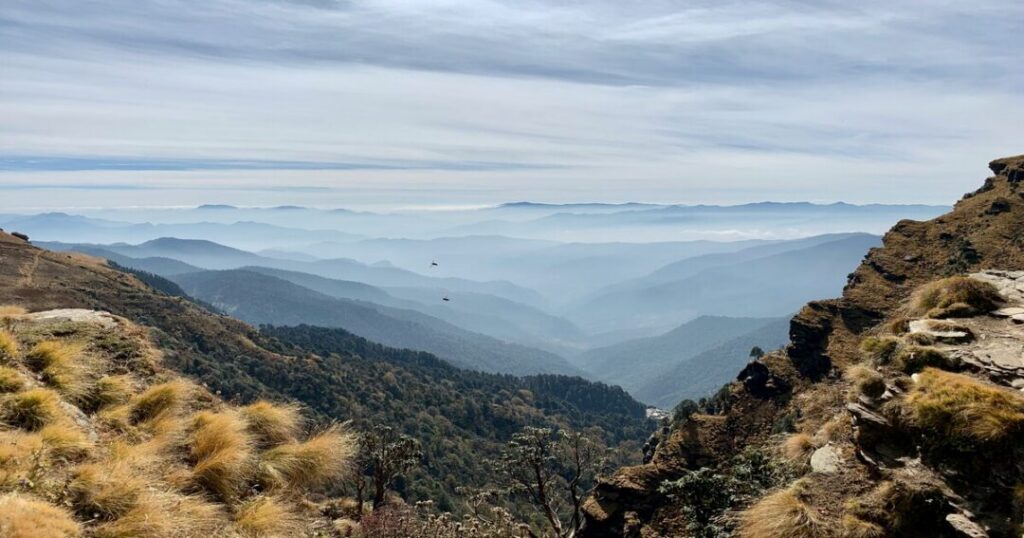
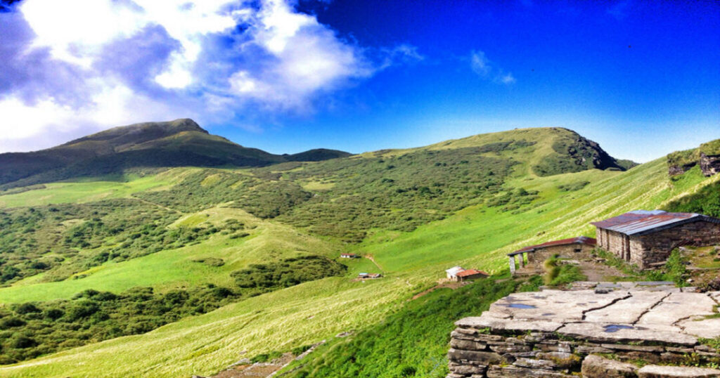
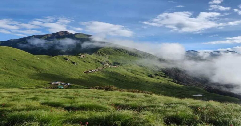
The trail emerges from the forest onto the open high-altitude meadows (bugyals) of Pitu Bugyal—one of the finest camping environments in the Garhwal. The bugyal is an open, rolling grassland at high altitude with panoramic views of the surrounding peaks. On clear days, Nanda Devi, Trishul, Hathi Ghoda Parbat, and the Kedarnath range are visible from the meadow.
- The transition from dense forest to open bugyal is sudden and dramatic—one of the finest moments on the trek
- Pitu Bugyal has no fixed facilities; carry tent and sleeping gear; water available from streams crossing the meadow
- Nights at Pitu Bugyal are cold—temperatures can drop to 0°C or below even in the trekking season; a -10°C sleeping bag is recommended
- Camp: Pitu Bugyal (~3,450–3,500 m)
Day 4: Pitu Bugyal to Rudranath Temple and Return to Panar
- Trek distance: ~4–5 km to temple + 9–10 km descent to Panar
- Starting altitude: ~3,450 m
- Temple altitude: ~3,559–3,600 m
- Trek time: Approximately 7–8 hours total
The final push to the Rudranath temple from Pitu Bugyal is approximately 4–5 km across open alpine terrain. The trail passes through more bugyal sections and a final rocky approach to the temple complex. The temple itself is a natural rock shrine—the face of Shiva in a rock formation, worshipped in the open under the sky. Around the main shrine are smaller temples, kunds (sacred water pools), and the natural pools of Surya Kund, Chandra Kund, and Tara Kund — sacred pools associated with different celestial bodies.
Also read: Kuari Pass Trek: The Complete Guide to the Curzon Trail & Pangarchulla Summit
At the Rudranath shrine:
- The main shrine is a natural rock formation—no enclosed structure over the deity
- A local pujari (priest) performs daily rituals; the atmosphere is intensely peaceful and remote
- The panoramic view from the temple includes Nanda Devi, Trishul, Kedarnath peak, Chaukhamba, and the Hathi Ghoda range—among the finest Himalayan panoramas from any pilgrimage site in Uttarakhand
After the temple visit and prayers, descend to Panar for the night.
- Camp: Panar (~2,900–3,000 m)
Day 5: Panar to Sagar Descent
- Trek distance: ~8–9 km | Altitude loss: ~900–1,000 m
- Trek time: Approximately 4–5 hours
- Return to Sagar; drive to Gopeshwar or Rishikesh
Rudranath Trek Route 2 — Mandal Village Route (Alternate Route)
The Mandal route is longer, less commonly used, and passes through the extraordinary meadow of Ansuiyataal and the hamlet of Nala. It is the preferred route for those approaching from the Chamoli side and provides a completely different landscape experience from the Sagar route.
Key stages:
- Mandal (~1,500 m) → Dumak (~2,400 m): ~8 km, 4–5 hours; through forest and small villages
- Dumak → Nala (~3,000 m): ~6 km, 3–4 hours; forest and meadow terrain
- Nala → Rudranath Temple (~3,559–3,600 m): ~10 km, 5–6 hours; open alpine meadow, bugyal, final approach to temple
Total one-way distance from Mandal: ~24 km
The Mandal route is particularly renowned for the Ansuiyataal area—a series of alpine meadows with exceptional birdwatching, wildflowers in season, and almost no other trekkers. It is the more rewarding approach for those who want solitude.
Can You Trek from Tungnath to Rudranath Through the High Ridge Traverse?
The Tungnath to Rudranath trek is one of the most spectacular and challenging ridge traverses in the Garhwal—connecting the second Panch Kedar (Tungnath, 3,680 m) to the third (Rudranath, ~3,559–3,600 m) via a high-altitude route through the Garhwal ridge.
Why this traverse is special: The route stays at high altitude for the majority of its length—crossing open bugyals, ridgelines, and remote terrain largely above 3,000 m throughout. It gives the rare experience of walking between two Panch Kedar temples on foot, through landscape that has virtually no other human presence outside the pilgrimage season.
Key facts about the traverse:
- Total distance: Approximately 35–40 km between the two temples via the ridge route
- Difficulty: Very difficult — sustained high-altitude terrain, no fixed facilities for extended sections, navigation challenging in low visibility
- Duration: 4–5 days for the traverse section alone
- Best time: Mid-May to June; September to October—avoid monsoon (July–August) when the ridgeline route is dangerous in rain
Standard traverse itinerary:
- Day 1: Chopta (Tungnath base) → Tungnath Temple (3,680 m) → Chandrashila summit (4,090 m) → descend to Dugalbitta (~2,900 m) camp
- Day 2: Dugalbitta → Rohini Bugyal (~3,200 m) camp — through dense forest and first open meadow sections
- Day 3: Rohini Bugyal → Pitu Bugyal (~3,450 m) — the long open bugyal traverse; this is the finest day of the route
- Day 4: Pitu Bugyal → Rudranath Temple → return to Panar camp
- Day 5: Panar → Sagar descent and drive to Gopeshwar
Important: The Tungnath to Rudranath trek is not recommended without a local guide who knows the ridge route—the trail between Dugalbitta and Rohini Bugyal is not well-marked, and navigational errors are common for first-time visitors. Cloud cover on the ridge can reduce visibility to near zero within minutes.
Also read: Kedarkantha Trek: The Complete Guide to India’s Best Winter Snow Trek
What is the Best Time to Do the Rudranath Trek?
| Season | Conditions | Recommended? |
| May to June | Temple open; rhododendrons in bloom; clear skies; moderate temperatures | ✅ Best for flowers and views |
| July to August (Monsoon) | Heavy rain; trails slippery; leeches; reduced visibility; ridge route dangerous | ❌ Not recommended |
| September to November | Post-monsoon clarity; excellent summit views; cooler temperatures, and the temple closes in November | ✅ Best for mountain views |
| December to April | Temple closed; heavy snow; trail inaccessible | ❌ Temple closed |
Temple opening and closing: The Rudranath temple follows the Panch Kedar calendar—typically opening in late April or May (on an auspicious date determined annually) and closing in October or November before winter. The winter deity moves to the Gopinath Temple in Gopeshwar. Always verify current-year opening dates before planning—they shift annually.
What Should You Know About Gear, Fitness, Permits, and AMS Before the Rudranath Trek?
Gear List
- Footwear: Waterproof trekking boots — mandatory; ankle support essential on the rocky upper sections
- Layers: Down jacket, fleece, thermal base layer, waterproof shell—temperatures drop sharply after sunset at Pitu Bugyal
- Sleeping bag: Rated to -10°C minimum
- Tent: Required for Pitu Bugyal and bugyal camping; no fixed camp structures in upper sections
- Trekking poles: Essential — particularly for the descent and the rocky approach to the temple
- Headlamp: For early morning departures
- Water purification: Carry iodine tablets or a filter—stream water in upper sections needs purification
Fitness
The Rudranath trek is rated difficult and is consistently considered the toughest of the Panch Kedar treks. You should be comfortable with 12–15 km per day at altitude, sustained uphill climbing for 5–6 hours, and camping in cold conditions. Prior Himalayan trekking experience is strongly recommended.
Permits
- Forest department registration is required at Sagar—carry valid government-issued photo ID
- The Rudranath area falls within the Kedarnath Wildlife Sanctuary buffer zone; regulations may apply—confirm current requirements at Gopeshwar forest department office before starting
AMS
The Rudranath temple (~3,600 m) is at a genuinely high altitude. Acclimatize at Sagar (2,000 m) for at least one night before beginning. The gradual altitude gain over 4–5 days is well-designed for acclimatisation, but do not push through AMS symptoms—descend immediately if headache, nausea, or dizziness worsens above 3,000 m.
Also read: Kalavantin Durg Trek: The Complete Guide to Maharashtra’s Most Thrilling Pinnacle
Conclusion about Rudranath Trek
The Rudranath trek is not the trek you take when you want comfort or convenience. It is the trek you take when you want the Himalayas without the crowds, the pilgrimage without the infrastructure, and the summit without the help. The reward—a natural rock face of Shiva worshipped under the open sky at 3,600 meters, surrounded by Himalayan peaks and high meadows—is proportional to the effort.
Quick recap:
- Temple altitude: ~3,559–3,600 m (11,677–11,800 ft)—3rd or 4th Kedar depending on pilgrimage sequence followed
- Sagar route: ~19–22 km one way; 4–5 days; main route
- Mandal route: ~24 km one way; 5–6 days; more remote
- Tungnath to Rudranath traverse: ~35–40 km; 4–5 days on the ridge; requires guide
- Best time: May–June (flowers); September–October (views)
- Difficulty: Difficult — toughest of the Panch Kedar treks
- What is worshipped: Shiva’s face (mukha) as Neelkantha Mahadev, natural rock, open sky
Download the Explurger app to log your Rudranath trek, discover what other pilgrims and trekkers recommend for current trail conditions, and plan your complete Panch Kedar yatra.
The pujari is already at the shrine. The bugle is already in flower. The face of Shiva is already looking out at the mountains. Go when you are ready.
FAQs about Rudranath Trek
2. What is the Rudranath trek route?
Two main Rudranath trek routes exist. The Sagar route (most popular): Sagar (~2,000 m) → Panar (~2,900–3,000 m) → Pitu Bugyal (~3,450 m) → Rudranath temple (~3,559–3,600 m); approximately 19–22 km one way. The Mandal route (longer, more remote): Mandal (~1,500 m) → Dumak → Nala → Rudranath; approximately 24 km one way, passing through the Ansuiyataal meadows. Both routes converge near the upper bugyal section.
3. What is the Rudranath trek difficulty?
The Rudranath trek is rated difficult—consistently described as the toughest of the five Panch Kedar treks. The trail involves sustained altitude gain, remote terrain with minimal facilities, cold camping above 3,000 m, and rocky approaches near the temple. Prior Himalayan trekking experience is strongly recommended. Fitness benchmark: comfortable with 12–15 km per day at altitude, cold camping, and 5–6 hours of daily ascent.
4. What is the best time for the Rudranath trek?
The Rudranath trekking season runs from approximately May to November, matching the temple's open period. May to June is best for rhododendron bloom, clear skies, and moderate temperatures. September to October offers post-monsoon clarity and the finest Himalayan views. Avoid July and August—monsoon makes the trail slippery and dangerous, particularly the ridge sections. The temple closes for winter in October or November; verify the current year's closing date before traveling.
5. What is the Tungnath to Rudranath trek?
The Tungnath to Rudranath trek is a high-altitude ridge traverse connecting the 2nd and 3rd Panch Kedar temples—approximately 35–40 km over 4–5 days, staying primarily above 3,000 m throughout. It passes through Dugalbitta, Rohini Bugyal, and Pitu Bugyal before reaching Rudranath. It is one of the most spectacular and challenging routes in the Garhwal Himalayas and requires a local guide for the unmarked ridge sections between Dugalbitta and Rohini Bugyal. Best time: May to June and September to October.
6. What is worshipped at Rudranath?
At Rudranath, the face (mukha) of Lord Shiva is worshipped as Neelkantha Mahadev—in a natural rock formation rather than a carved idol or enclosed temple. There is no roof over the main deity; the face of Shiva is a naturally formed rock, worshipped in the open under the Himalayan sky. This makes Rudranath the most elemental and primal of the Panch Kedar shrines—an open-sky natural temple at approximately 3,559–3,600 meters, accessible only on foot, with no facilities other than a seasonal pujari and basic water sources.