![]()
Ask any trekking guide in Uttarakhand which peak they’d send a first-time Himalayan trekker to, and the answer is almost always the same: the Kedarkantha Trek. Sitting at 3,810 meters (12,500 feet) in the Govind Wildlife Sanctuary of Uttarkashi district, the Kedarkantha Trek is high enough to deliver genuine Himalayan summit views, accessible enough not to require mountaineering experience, and beautiful enough in all four seasons that it has become the benchmark by which every other beginner Himalayan trek is measured. In winter, the Kedarkantha Trek is India’s most celebrated snow trek. In summer and spring, it transforms into a wildflower-and-meadow experience that looks nothing like the winter version and is no less extraordinary. This guide covers the Kedarkantha peak trek in full—both seasons, every campsite, the summit push, and everything you need to prepare.
Why Kedarkantha? What Makes It Special
The Kedarkantha trek earns its reputation from multiple directions:
In winter: The entire route—from Sankri to Juda Ka Talab to the base camp—is buried under deep snow. The summit push before dawn, the first light hitting the Bandarpoonch and Swargarohini ranges, and the 360-degree panorama of some of the Himalaya’s most famous peaks—Yamunotri, Gangotri, Kedarnath, and Badrinath ranges all visible on a clear day—make this the finest winter summit experience accessible to beginners in India.
In summer and autumn: The snow melts to reveal dense forests of oak, rhododendron, and deodar cedar between 2,000 and 3,000 meters. Meadows burst with wildflowers—primulas, anemones, and Himalayan herbs. The clarity of the summit views rivals winter. The trails are clear, the campsites are green, and the crowds are significantly smaller.
Year-round: The trail passes through traditional villages, dense Himalayan forest, the extraordinary lake of Juda Ka Talab, and a base camp clearing that frames the summit cone in a way no photograph fully captures.
Kedarkantha Trek—Key Facts
| Detail | Info |
| Summit altitude | 3,810 m (12,500 ft) |
| Base camp altitude | ~3,430 m (11,250 ft) |
| Base village | Sankri, Uttarkashi district |
| Sankri altitude | ~1,950 m (6,400 ft) |
| Located in | Govind Wildlife Sanctuary, Uttarkashi, Uttarakhand |
| Total trek distance | ~20 km round trip |
| Duration | 5–6 days (including travel from Dehradun) |
| Difficulty | Easy to Moderate |
| Best season (winter) | December to early April (snow trek) |
| Best season (summer) | May to June, mid-September to November |
| Nearest airport | Jolly Grant Airport, Dehradun (~200 km from Sankri) |
| Nearest railway station | Dehradun Railway Station (~200 km from Sankri) |
Kedarkantha Trek Best Time—Season by Season
Winter (December to Early April)—The Snow Trek
The best time for the Kedarkantha trek for most people is the winter window—when the snowfall transforms the trail into something genuinely extraordinary. December and January bring heavy snowfall; the trail from Sankri becomes a snow path, Juda Ka Talab freezes solid, and the summit itself requires microspikes or crampons. February and March offer snow that has settled and consolidated—easier underfoot, still deep and beautiful.
- December to January: heaviest snowfall, most dramatic conditions, temperatures can drop to -10°C or lower at night at higher camps
- February to March: settled snow, clear skies, excellent summit conditions
- Early April: snow beginning to melt; still significant snow at higher elevations
Summer and Spring (May to June, September to November)
The Kedarkantha trekking experience in non-winter months is underrated. The trail is clear, the forest is richly green, wildflowers cover the meadows at Juda Ka Talab and the base camp, and the summit views—with no cloud haze—can be sharper than winter.
- May to June: wildflowers in bloom, comfortable temperatures, excellent visibility
- July to August: monsoon—not recommended; trails become slippery and leeches are common
- September to November: post-monsoon clarity, rhododendron forests, cool temperatures, much smaller crowds
Monsoon (July to August) — Avoid
Heavy rainfall makes the trails slippery and dangerous. Most organized groups suspend Kedarkantha operations during the peak monsoon. This is the one window to avoid.
How to Reach Sankri (Kedarkantha Base Village)
Sankri is the base for the Kedarkantha trek—a village at approximately 1,950 meters in the Tons Valley, Uttarkashi district.
From Dehradun (~200 km | 8–10 hours by road):
- The road route goes: Dehradun → Mussoorie → Purola → Mori → Naitwar → Sankri
- Shared jeeps and private cabs operate from Dehradun toward Sankri; the journey takes approximately 8–10 hours depending on road conditions—verify current road status before traveling.
- The road passes through spectacular Tons Valley scenery—one of the most beautiful drives in Uttarakhand
Getting to Dehradun:
- By train from Delhi (approximately 6 hours; multiple overnight options)
- By air: Jolly Grant Airport, Dehradun is connected to Delhi, Mumbai, and other major cities
- By road: Delhi to Dehradun approximately 300 km, 5–6 hours
At Sankri:
- Guesthouses and homestays are available; book in advance for December–February (peak season)
- Sankri has the last reliable mobile network and ATM connectivity—carry sufficient cash before proceeding
Kedarkantha Trek Itinerary — Full Day-by-Day Breakdown
This is the standard 5-day itinerary (from Sankri) used by most trekking groups. Day 1 is typically the Dehradun to Sankri drive.
Day 1: Dehradun to Sankri
- Mode: Road (~200 km, 8–10 hours)
- Altitude: Arrive Sankri at ~1,950 m (6,400 ft)
- A long but spectacular drive through the Tons Valley
- Acclimatise, check gear, get an early night
- Last ATM point before the trek; last reliable mobile signal
Day 2: Sankri to Juda Ka Talab
- Distance: Approximately 4–4.5 km | Altitude gain: ~750 m
- Starting altitude: ~1,950 m | Ending altitude: ~2,700 m (8,858 ft)
- Trek time: Approximately 4–5 hours
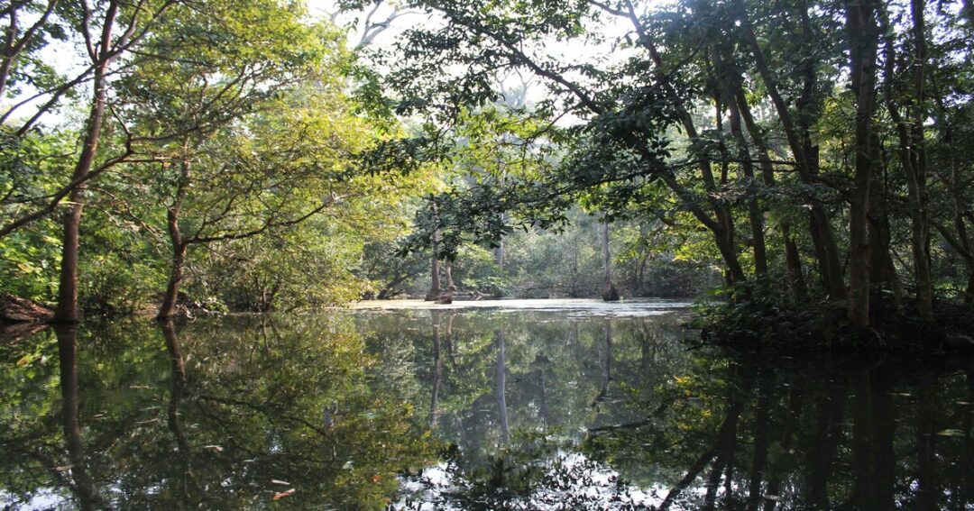
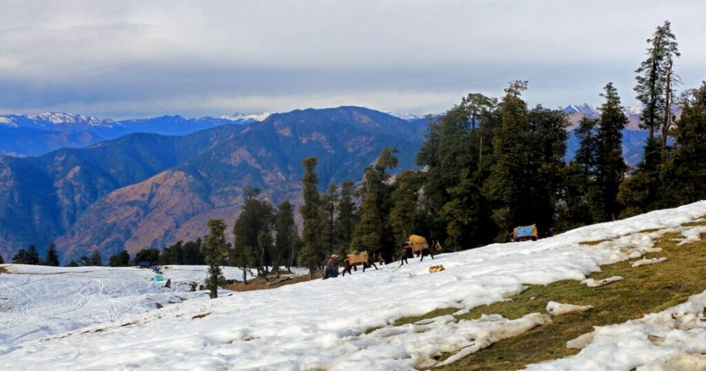
The first day of actual trekking takes you from Sankri through oak and rhododendron forest, past the small village of Phata, and up through increasingly dense Himalayan forest to Juda Ka Talab—a sacred high-altitude lake that freezes completely in winter and becomes a clear reflective pool surrounded by wildflower meadows in summer. It is the most photographed campsite on the Kedarkantha trek.
- The forest cover on this section is extraordinary—deodar cedar, rhododendron, and oak form a dense canopy
- Multiple short climbs and flat sections; a good warm-up day
- Swargarohini peak is visible from Juda Ka Talab on clear days
- Campsite: Juda Ka Talab (~2,700 m)
Day 3: Juda Ka Talab to Kedarkantha Base Camp
- Distance: Approximately 4–4.5 km | Altitude gain: ~730 m
- Starting altitude: ~2,700 m | Ending altitude: ~3,430 m (11,250 ft)
- Trek time: Approximately 4–5 hours
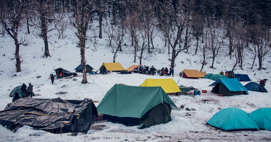
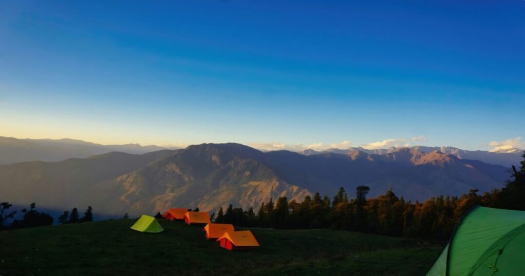
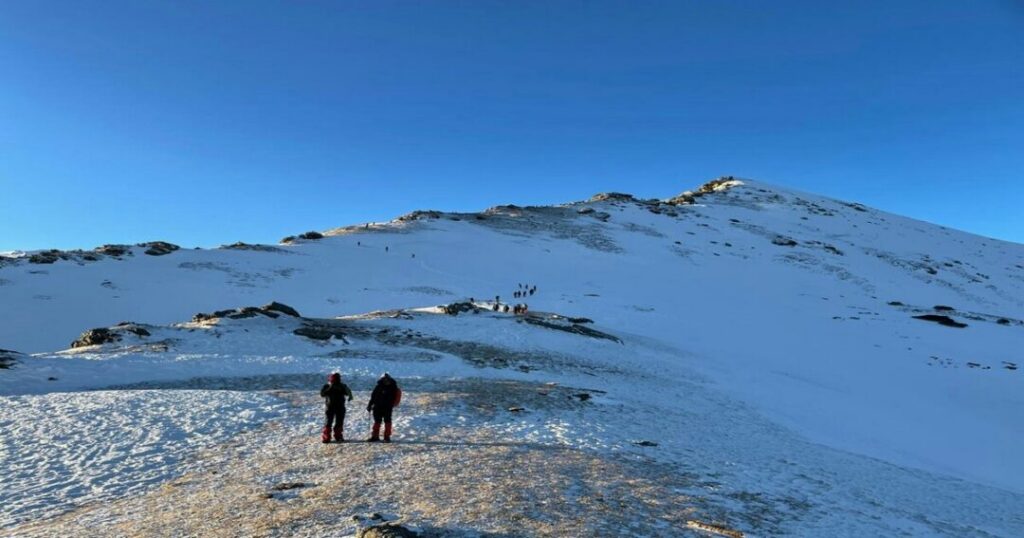
The second trekking day takes you from the lake through thickening pine and rhododendron forest and then out into open terrain as the treeline recedes and the Kedarkantha summit cone comes into full view for the first time. The base camp is a wide, open clearing at approximately 3,430 meters—perfectly positioned for a view of the summit directly above.
- This section involves a steady, sustained climb—the most physically demanding full day of the trek
- The transition from dense forest to open alpine meadow is dramatic and sudden
- On clear winter days, the base camp is already blanketed in deep snow; the summit—380 meters above—looks both close and formidable
- Campsite: Kedarkantha Base Camp (~3,430 m)
Also read: Kalavantin Durg Trek: The Complete Guide to Maharashtra’s Most Thrilling Pinnacle
Day 4: Summit Push and Return to Sankri (or Juda Ka Talab)
- Summit altitude: 3,810 m (12,500 ft) | Altitude gain from base camp: ~380 m
- Summit push time: Approximately 3–4 hours from base camp to summit
- Summit to Sankri: Approximately 5–6 hours descent
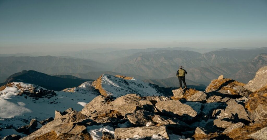
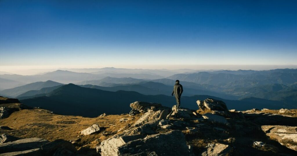
This is the Kedarkantha summit day—and it typically starts before dawn. Groups usually leave base camp in the early pre-dawn hours to reach the summit for sunrise. The summit push from base camp involves a final 380-meter climb across open terrain—in winter over snow and ice—to the Kedarkantha peak at 3,810 meters.
At the summit:
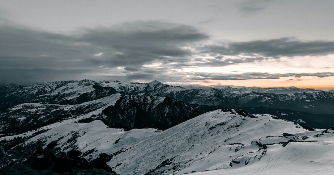
- 360-degree panoramic views of the Himalayan ranges: Bandarpoonch, Swargarohini, Black Peak, Yamunotri, Gangotri, Kedarnath, and Badrinath ranges all visible on clear days
- A small Shiva temple at the summit—the name Kedarkantha reflects this: Kedar is a name for Lord. Shiva; Kantha means “throat” in Sanskrit—the peak is associated with Shiva
- The sunrise from the Kedarkantha peak in winter, with the valley below filled with snow and the sky turning pink behind the Swargarohini group, is one of the finest experiences in Indian trekking
Descent options:
- Option A (standard): Descend from summit back to base camp, then continue down to Sankri all in one long day (~12 km total)
- Option B (recommended): Descend to Juda Ka Talab for the night, then continue to Sankri on Day 5—allows a gentler pace and one more night in the forest
Day 5: Return to Sankri (if Option B) + Drive to Dehradun
- Juda Ka Talab to Sankri: Approximately 4 km, 2–3 hours
- Sankri to Dehradun: ~200 km, 8–10 hours by road
- Reach Dehradun by evening; book onward travel after 9 PM to be safe
Practical Tips — Gear, Fitness, Permits & AMS
Gear List
Essential for winter:
- Footwear: Waterproof trekking boots, rated for sub-zero temperatures; wool socks (multiple pairs)
- Microspikes/crampons: Mandatory for the summit push in winter—ice traction devices are essential
- Gaiters: To prevent snow from entering boots on the deeper snow sections
- Layering: Thermal base layer (wool or synthetic), fleece mid-layer, down jacket, waterproof outer shell
- Sleeping bag: Rated to -10°C minimum for winter; -5°C for spring/autumn
- Gloves: Thin inner gloves + heavy outer mitts; numb fingers make the summit push genuinely difficult
- Balaclava/neck gaiter: Essential for pre-dawn summit push in temperatures that can drop to -10°C or lower
- Trekking poles: Highly recommended for descent stability on snow
Essential for all seasons:
- Headlamp: For the pre-dawn summit push; carry spare batteries
- Sun protection: SPF 50+ sunscreen, UV sunglasses, and a brimmed hat—Himalayan UV at altitude is intense
- Water: 2 litres minimum; electrolyte sachets
- First aid: Personal kit including blister care; altitude sickness medication (consult a doctor before carrying)
Altitude and AMS
The Kedarkantha trek reaches 3,810 meters—significant enough that Acute Mountain Sickness (AMS) is a genuine consideration.
- Acclimatise at Sankri (1,950 m) for at least one night before beginning the trek
- Symptoms of AMS: headache, nausea, dizziness, fatigue, loss of appetite
- The itinerary’s gradual altitude gain (Sankri 1,950 m → Juda Ka Talab 2,700 m → Base Camp 3,430 m → Summit 3,810 m) is well-designed for acclimatization.
- Golden rule: If symptoms worsen, descend immediately—do not push through AMS at altitude
- Stay hydrated; avoid alcohol for the first 48 hours on the trail.
Also read: Top Winter Treks in India–Best Trails From North to South
Permits
The Kedarkantha trek falls within Govind Wildlife Sanctuary—a permit is required for entry.
- Forest department permits are obtained through the trekking operator at Sankri or directly at the forest department office
- Carry valid government-issued photo ID (Aadhaar or Passport); foreign nationals should verify current permit requirements before travel
- A registration fee is typically applicable; confirm the current amount at the time of booking
Fitness
The Kedarkantha trek difficulty is easy to moderate—accessible to fit beginners with no prior Himalayan trekking experience. You should be comfortable:
- Walking 10–12 km per day with a loaded daypack
- Sustained uphill climbing for 3–5 hours
- Operating in cold conditions (particularly relevant for winter)
Preparation: 4–6 weeks of regular cardio (running, stair climbing, cycling) and practice walks with a loaded backpack make the difference between struggling and enjoying the experience.
Conclusion
The Kedarkantha trek earns every superlative it gets. It is genuinely one of the finest experiences in Indian trekking—a summit that delivers Himalayan views you’d expect from a technically demanding peak, via a trail that a fit, well-prepared beginner can complete with confidence.
Quick recap:
- Summit: 3,810 m (12,500 ft) — Govind Wildlife Sanctuary, Uttarkashi
- Distance: ~20 km round trip from Sankri
- Duration: 5–6 days including Dehradun travel
- Best time (winter): December to March—snow trek, frozen lake, pre-dawn summit for sunrise
- Best time (other): May–June, September–November—wildflowers, clear views, smaller crowds
- Difficulty: Easy to moderate; crampons essential in winter
- Base: Sankri village, ~200 km from Dehradun
- Permit: Required—Govind Wildlife Sanctuary forest department
Download the Explurger app to log your Kedarkantha trek experience, discover what other trekkers say about current trail conditions, and plan your next Himalayan adventure.
The summit is already there. Sankri is waiting. The only question is which season calls you first.
Also read: Dayara Bugyal Trek: The Complete Guide to Uttarakhand’s Most Beautiful Meadow
FAQs About Kedarkantha Trek
2. What is the Kedarkantha peak altitude?
The Kedarkantha peak sits at 3,810 meters (12,500 feet) above sea level in the Govind Wildlife Sanctuary, Uttarkashi district, Uttarakhand. The base camp is at approximately 3,430 meters (11,250 feet), making the final summit push from base camp approximately 380 meters of altitude gain. The Kedarkantha summit offers 360-degree views of major Himalayan ranges, including Bandarpoonch, Swargarohini, Black Peak, and the Yamunotri, Gangotri, Kedarnath, and Badrinath groups.
3. How long does the Kedarkantha trek take?
The standard Kedarkantha trek itinerary takes 5–6 days in total — Day 1 is the Dehradun to Sankri drive (~8–10 hours), Days 2–3 are the ascent to base camp via Juda Ka Talab, Day 4 is the summit push and descent, and Day 5 is the return to Sankri and drive back to Dehradun. The total trekking distance is approximately 20 km round trip.
4. Is the Kedarkantha trek good for beginners?
Yes—the Kedarkantha trek is one of the most recommended first Himalayan treks precisely because of its gradual altitude gain, well-marked trail, and absence of technical climbing. However, the winter version requires microspikes or crampons for the summit push and appropriate cold-weather gear rated to sub-zero temperatures. Any beginner attempting the winter trek should go with an experienced guide and ensure their gear is adequate for the conditions.
5. What can you see from the Kedarkantha summit?
From the Kedarkantha summit on a clear day, visible peaks include Bandarpoonch, Swargarohini, Black Peak (Kala Nag), and the ranges associated with Yamunotri, Gangotri, Kedarnath, and Badrinath. The 360-degree panorama is one of the finest accessible from any beginner-friendly trek in India. In winter, the view of the snow-covered Tons Valley far below combined with the Himalayan skyline makes the pre-dawn summit push—arriving for sunrise—one of the most memorable experiences in Indian trekking.
6. Do I need a permit for the Kedarkantha trek?
Yes—the Kedarkantha trek route passes through Govind Wildlife Sanctuary, which requires a forest department entry permit. Permits are typically arranged through the trekking operator at Sankri or directly at the forest department office. Carry valid government-issued photo ID. Foreign nationals should verify current permit requirements before travel, as regulations for wildlife sanctuary areas can change.