![]()
If you are looking for your first real Himalayan trek — the kind where you camp in snow, slide down a mountain on your back, wake up to views of the Greater Himalayas, and walk through a village that has not changed in a century — the Sar Pass trek is where most Indian trekkers begin. Nestled in the Parvati Valley of Kullu district, Himachal Pradesh, it climbs from the backpacker haven of Kasol through dense deodar and rhododendron forest, past remote Himalayan hamlets, across high-altitude meadows (thaches), and up to the Sar Pass at approximately 4,220 meters (13,850 feet)—where the descent on the other side involves a snow slide that has become one of the most photographed moments in Indian trekking.
The name “Sar” means “lake” in the local Kullvi dialect—named after a small, usually frozen lake that trekkers pass near the summit. This guide covers everything: the key facts, the full day-by-day itinerary with all campsite altitudes, the best time, the difficulty, and the cost.
Sar Pass Trek: Key Facts You Should Know
The Sar Pass Trek is one of the most popular Himalayan treks in Parvati Valley, Himachal Pradesh. Known for its scenic forests, snow-covered trails, and beginner-friendly route, this trek is ideal for adventure seekers looking for a moderate Himalayan experience. Starting from Kasol and ending at Barshaini, the trek offers stunning views of the surrounding peaks and valleys.
Quick Overview of Sar Pass Trek
| Detail | Info |
|---|---|
| Altitude | ~4,220 m (13,850 ft) |
| Base Camp Height | Kasol: ~1,580–1,650 m |
| Distance | ~48 km |
| Duration | 5–6 days |
| Difficulty Level | Moderate |
| Trek Route | Kasol → Grahan → Min Thach → Nagaru → Sar Pass → Biskeri → Barshaini |
| Location | Parvati Valley, Kullu district, Himachal Pradesh |
| Nearest Airport | Bhuntar (~31 km from Kasol) |
| Nearest Railway Station | Joginder Nagar (~144 km) |
| Best Season | April–June, September–November |
| Minimum Age | 14 years |
The Sar Pass Trek is perfect for trekkers who want a balanced mix of adventure and accessibility. Its moderate difficulty makes it suitable for first-time Himalayan trekkers with basic fitness, while the changing landscapes—from dense pine forests to snowy mountain passes—make the journey unforgettable.
Also read: Kedarkantha Trek: The Complete Guide to India’s Best Winter Snow Trek
What Makes the Sar Pass Trek Special
Three things set the Sarpass trek apart from other beginner-friendly Himalayan routes:
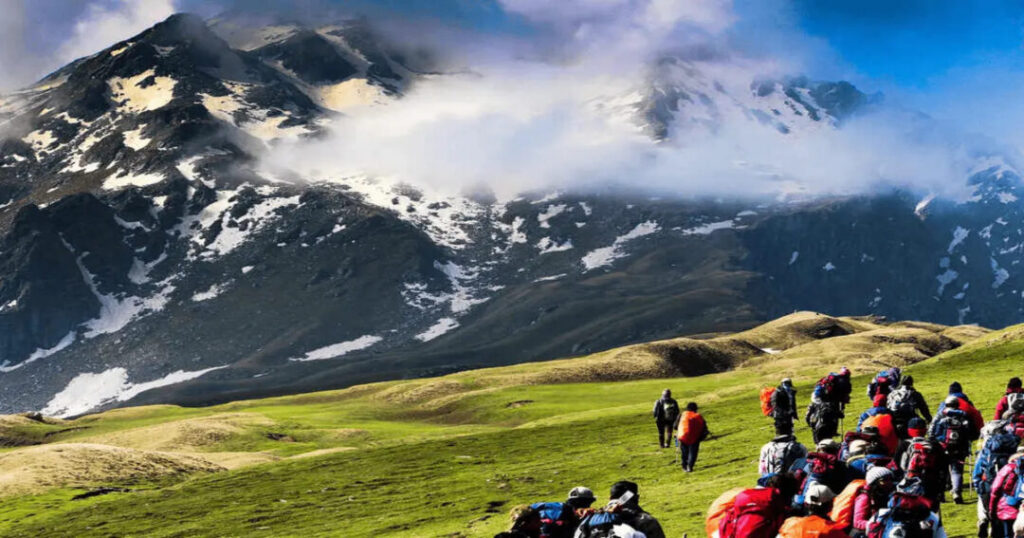
The terrain variety: No other beginner trek in Himachal Pradesh packs this many landscape types into five days—tropical forest at the base, dense deodar and rhododendron canopy, river crossings, open high-altitude meadows (thaches) thick with wildflowers in June, snow fields from Nagaru upward, a technical pass crossing, and a descent that involves a genuine snow slide. The diversity keeps every day interesting.
The cultural texture: The trail passes through Grahan — a traditional Himalayan village of wooden houses, slate roofs, stone pathways, and terraced fields — that is completely roadless and accessible only on foot. The village offers a genuine encounter with the Kullvi mountain community that most Himalayan treks skip entirely in the rush to reach altitude.
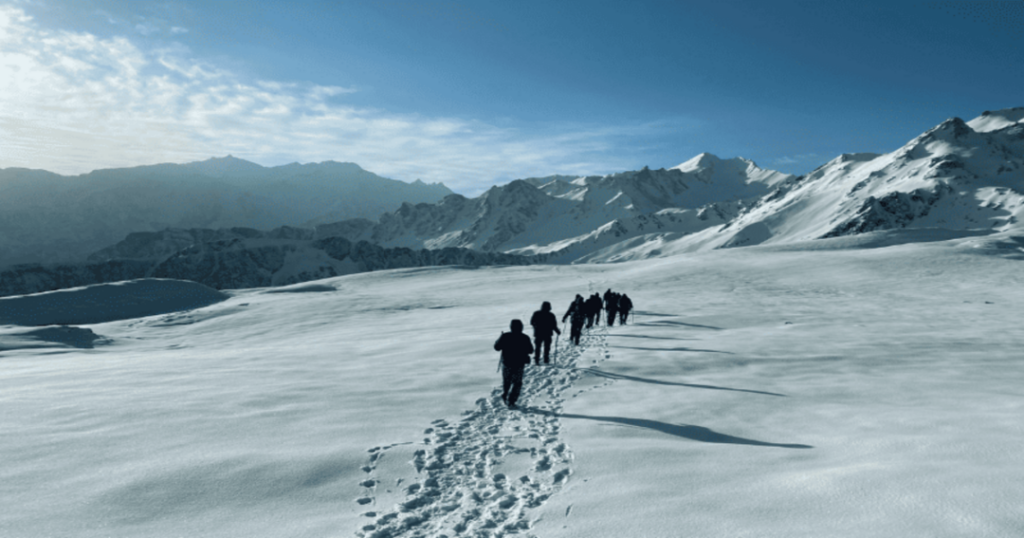
The snow slide: The descent from Sar Pass to Biskeri involves a near-vertical snow slope that, in May and June when snow conditions are right, becomes one of the most exhilarating experiences on any beginner trek—sliding down on your back, feet first, with the valley spread below you. This single moment is why the Sar Pass trek has remained one of the most popular treks in North India for decades.
How to Reach Kasol (Trek Base)
Kasol in Parvati Valley, Kullu district, is the base for the Sar Pass trek.
From Delhi (~520 km | 12 hours):
- Overnight buses from Delhi ISBT Kashmere Gate to Kasol—several operators run direct services, typically departing between 5 PM and 10 PM and arriving at Kasol bus stand around 6–8 AM
- Or: overnight bus to Bhuntar (the closest town with a small airport), then a shared taxi or local bus to Kasol (~30 km, 1 hour)
From Chandigarh (~270 km | 6–7 hours):
- Overnight or afternoon buses from Chandigarh ISBT to Kasol
- Or: bus to Bhuntar, then taxi/bus to Kasol
From Manali (~78 km | 2.5–3 hours):
- By road via Naggar and Kullu; shared jeeps and taxis available
By air: Bhuntar Airport (Kullu-Manali Airport) — approximately 31 km from Kasol; connected to Delhi
Sar Pass Trek Route — Full Day-by-Day Itinerary
Standard 5-Day Itinerary
Day 0 / Arrival Day: Kasol Base Camp
- Altitude: Kasol ~1,580–1,650 m (5,184–5,413 ft)
- Arrive at Kasol, check into base camp, complete registration and gear check
- Acclimatisation walk in the Parvati Valley surroundings
- Trek briefing; deposit extra luggage not needed on trail
- Night: Kasol base camp
Kasol—often called the “Mini Israel of India” for the large number of Israeli travelers who made it famous in the 1990s—sits on the banks of the Parvati River surrounded by pine forest. It is a small, well-connected village with accommodation, restaurants, and the unmistakable backpacker energy that makes it one of Himachal Pradesh’s most distinctive base towns.
Also read: Kuari Pass Trek: The Complete Guide to the Curzon Trail & Pangarchulla Summit
Day 1: Kasol to Grahan Village
- Trek distance: ~9–10 km | Altitude gain: ~1,100 m
- Starting altitude: Kasol ~1,650 m | Ending altitude: Grahan ~2,730 m (8,957 ft)
- Trek time: Approximately 5–6 hours
The first day is the cultural centerpiece of the Sar Pass trek route—a steady climb from the Parvati River valley through increasingly dense forest to the remote village of Grahan. The trail crosses a bridge over the Parvati River immediately out of Kasol and begins ascending through deodar and pine forest, passing a waterfall section mid-route.
Grahan village sits at approximately 2,730 meters and is completely inaccessible by road—the only way in or out is on foot. The village has traditional wooden Kullvi architecture: interlocked deodar logs, slate roofs, carved wooden window frames, and a small temple. The residents maintain a lifestyle of subsistence farming, pastoralism, and the occasional trekker passing through their mountain home.
- The forest section between Kasol and Grahan is one of the finest deodar canopy walks in Himachal Pradesh
- Grahan has a small shop and a basic tea house run by villagers; most organised groups camp outside the village
- In May–June, wildflowers line the trail above the forest zone
- Camp: Grahan (~2,730 m)
Day 2: Grahan to Min Thach (Ming Thach)
- Trek distance: ~8–9 km | Altitude gain: ~600–700 m
- Starting altitude: Grahan ~2,730 m | Ending altitude: Min Thach ~3,300–3,400 m (10,827–11,155 ft)
- Trek time: Approximately 5–6 hours
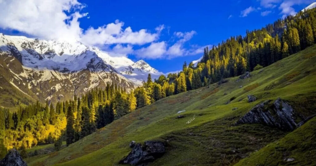
The trail from Grahan continues through a mix of forest and increasingly open terrain, passing smaller settlements before emerging onto the lower thach (high-altitude meadow) sections. Min Thach (also written Ming Thach) is the first genuine high-altitude meadow camp of the trek—an open, flat clearing surrounded by higher ridges, with the first significant snow visible on the peaks above.
- The first views of the Greater Himalayan snowline appear on this day—the transition from forested valley to alpine landscape is one of the most dramatic on the route
- Temperature at Min Thach drops sharply after sunset—layers are essential from this night onward
- Water is available from streams crossing the meadow
- Camp: Min Thach (~3,300–3,400 m)
Day 3: Min Thach to Nagaru
- Trek distance: ~5–6 km | Altitude gain: ~900–1,000 m
- Starting altitude: Min Thach ~3,300–3,400 m | Ending altitude: Nagaru ~4,000–4,100 m (13,123–13,451 ft)
- Trek time: Approximately 5–6 hours
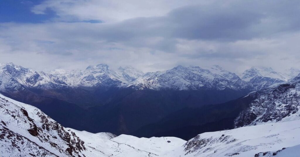
The most demanding day of the Sar Pass trekking experience — a steep, sustained climb from Min Thach to Nagaru, the high camp just below the pass. Snow begins underfoot from approximately 3,600 m; by Nagaru, trekkers are fully in the snowfield. The views from Nagaru camp — directly facing the Sar Pass couloir and with the Tosh Valley and Parvati Valley spread below — are extraordinary.
Nagaru is often called the “spine-chilling “camp”—night temperatures here drop well below freezing even in May and June. The camp is exposed on the ridge, and wind can be severe. This is the night when sleeping bag quality matters most.
- Microspikes or gaiters are useful from this section onward depending on snow conditions
- The altitude at Nagaru (~4,000–4,100 m) is the highest camp on the trek—AMS symptoms can appear here; monitor headache and nausea
- The sunrise from Nagaru—with the Greater Himalayan peaks turning orange in the first light—is one of the finest in the Parvati Valley
- Camp: Nagaru (~4,000–4,100 m)
Also read: Kudremukh Trek: Everything You Need to Know Before Conquering Karnataka’s Iconic Peak
Day 4: Nagaru to Sar Pass Summit and Descent to Biskeri Thach
- Trek distance: ~9–10 km | Altitude: Summit at ~4,220 m; descent to ~3,400 m
- Trek time: Approximately 7–8 hours
The summit day — the physical and emotional climax of the Sar Pass trek. The trek begins at pre-dawn (typically 4:30–5:00 AM) to reach the pass before clouds build in the afternoon. The approach from Nagaru is a steep snow climb up the couloir—using hands in sections and stamping footholds, the summit visible above the entire time.
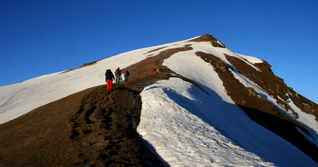
At the Sar Pass summit (~4,220 m / 13,850 ft): Panoramic views of the Greater Himalayan range, the Parvati and Tosh valleys, and — on a clear day — distant peaks including Deo Tibba. The small frozen lake (Sár) that gives the pass its name is visible nearby. The pass itself is a narrow ridge; the wind is typically significant.
The snow slide: The descent from the pass toward Biskeri is down a near-vertical snow slope—in proper snow conditions (May–June), this becomes the famous slide: sitting on your back, feet first, using your palms as brakes, sliding several hundred meters into the valley below. This is the most talked-about moment of the entire Sar Pass trek experience.
- The snow slide is only possible when snow conditions allow—in September/October the slope may be dry scree; verify conditions before expecting it
- The descent to Biskeri Thach after the slide is a further 3–4 km across meadow terrain
- Camp: Biskeri Thach (~3,400 m)
Day 5: Biskeri Thach to Barshaini—and Drive to Kasol
- Trek distance: ~10–12 km descent | Altitude loss: ~2,200 m
- Starting altitude: Biskeri Thach ~3,400 m | Ending altitude: Barshaini ~1,900 m (6,234 ft)
- Trek time: Approximately 5–6 hours; then ~15 km drive to Kasol
The final descent from Biskeri through forest and Himalayan village terrain to Barshaini—the last motorable point in Parvati Valley, from where the drive back to Kasol takes approximately 30–45 minutes. Barshaini is also the trailhead for other Parvati Valley treks, including Kheerganga and Pin Parvati Pass.
- The descent from Biskeri is steep in sections; trekking poles recommended
- Barshaini has basic facilities; the drive back to Kasol completes the circuit
- Most operators drop trekkers at the Kasol market by early afternoon on the final day
Best Time for the Sar Pass Trek
| Season | Conditions | Recommended? |
| April to June (Spring/Summer) | Snow conditions ideal for the summit slide; rhododendrons in bloom April–May; wildflowers in June; clear mornings | ✅ Best overall — snow slide possible; most popular window |
| July to August (Monsoon) | Heavy rainfall; trails slippery; river crossing at Kasol can be dangerous; leeches | ❌ Not recommended |
| September to November (Autumn) | Post-monsoon clarity; best mountain views; no snow for the slide; stable weather | ✅ Good — excellent views, no snow slide |
| December to March (Winter) | Heavy snow; trail inaccessible; pass closed | ❌ Trek closed |
The single best window: May to mid-June — snow in ideal condition for the slide, rhododendrons finished but meadow wildflowers beginning, and temperatures manageable at all camps.
Also read: Rudranath Trek: The Complete Guide to the Most Remote Panch Kedar
Sar Pass Trek Cost — What to Expect
The Sar Pass trek cost varies by operator, season, and group size. A general framework:
Organized package (with operator):
- Most reputable operators charge approximately ₹8,000–₹14,000 per person for a 5-day package inclusive of camping, meals, guide, and permits
- The Indiahikes Sar Pass trek (run by Indiahikes) is one of the most widely cited packages—they maintain their own campsites and equipment standards; prices are at the higher end of the range
- Budget operators run cheaper packages; verify equipment quality and safety standards before booking
Self-organized:
- Accommodation at Kasol: widely available from basic guesthouses to cafés with dorm beds
- Guide: a local guide from Kasol or Grahan is strongly recommended; negotiate locally
- Camping equipment: available for rent in Kasol
Note: All prices are approximate and subject to seasonal variation. Verify current rates with operators.
Practical Tips — Gear, Fitness & AMS
Gear List
- Footwear: Waterproof trekking boots with ankle support—mandatory above Grahan
- Layers: Down jacket, fleece, thermal base layer, waterproof shell—nights at Nagaru can drop to -5°C to -10°C
- Sleeping bag: -10°C rated—mandatory for Nagaru camp
- Trekking poles: Strongly recommended from Min Thach onward
- Sunscreen & UV sunglasses: UV intensity on the snowfields is severe
- Gaiters: Useful for the snow sections above 3,500 m
Also read: Sandakphu Trek: The Complete Guide to West Bengal’s Highest Peak & Phalut Extension
Sar Pass Trek Difficulty Level
Moderate — the Sar Pass trek difficulty level is rated moderate and is specifically considered one of India’s finest introductory Himalayan treks. No prior Himalayan experience is required. The key demands are sustained uphill walking (Days 1–3), altitude adaptation (Nagaru at ~4,000+ m), and the confidence to manage the summit snow slope. Basic cardiovascular fitness — comfortable walking 8–10 km with a loaded pack — is sufficient.
AMS
The Sar Pass trek’s altitude of ~4,220 m is significant enough to trigger AMS in susceptible trekkers. The gradual ascent over 3 days is well-designed for acclimatization, but monitor for persistent headache, nausea, and dizziness above Nagaru. Descend immediately if symptoms worsen.
Conclusion: Sar Pass trek
The Sar Pass trek earns its reputation as the best beginner Himalayan trek for one simple reason: it gives you everything—a real Himalayan village, a snow field, a summit at over 4,000 meters, and a descent you will describe to everyone you know for years—within a five-day format accessible from Delhi on a Friday overnight bus.
Quick recap:
- Sar Pass height: ~4,220 m (13,850 ft), Parvati Valley, Kullu district
- Sar Pass trek distance: ~48 km over 5 days
- Route: Kasol → Grahan → Min Thach → Nagaru → Sar Pass → Biskeri → Barshaini
- Difficulty: Moderate — India’s best beginner Himalayan trek
- Best time: May–June (snow slide); September–October (clearest views)
- Cost: ~₹8,000–₹14,000 organised package
- The moment: Snow slide from the pass—as good as it sounds
Download the Explurger Social Travel App to log your Sar Pass trek, discover what other trekkers say about current trail and snow conditions, and plan your next Parvati Valley adventure.
Kasol is already waiting. The snow is already on the pass. The only question is which bus you’re taking on Friday night.
FAQs About Sar Pass Trek
2. What is the Sar Pass trek distance?
The Sar Pass trek distance is approximately 48 km for the standard 5-day itinerary (Kasol to Barshaini). Some sources cite the full circuit at up to 70 km depending on the exact route and measurement method. The day-by-day breakdown is approximately the following: Day 1 Kasol–Grahan (~9–10 km), Day 2 Grahan–Min Thach (~8–9 km), Day 3 Min Thach–Nagaru (~5–6 km), Day 4 Nagaru–Sar Pass–Biskeri (~9–10 km), and Day 5 Biskeri–Barshaini (~10–12 km).
3. What is the Sar Pass trek difficulty level?
The Sar Pass trek difficulty level is rated moderate — it is considered one of India's best introductory Himalayan treks, suitable for first-time high-altitude trekkers with basic fitness. No prior trekking experience is required, though the minimum age for most organized operators is 14 years. The most demanding elements are the Day 3 climb to Nagaru (~4,000–4,100 m) and the summit day pre-dawn start. The famous snow slide on the descent from the pass is a highlight, not a hazard, in appropriate snow conditions.
4. What is the best time for the Sar Pass trek?
The Sar Pass trek's best time is May to mid-June—the optimal window for snow conditions that enable the summit slide, wildflowers on the meadows, clear mornings, and manageable temperatures at all camps. September to November is also excellent for clear mountain views and stable weather, though the snow slide is typically not possible then. Avoid July and August (monsoon—dangerous river crossings, slippery trails) and December to March (trek closed due to heavy snow).
5. How much does the Sar Pass trek cost?
The Sar Pass trek cost for an organized package typically ranges from approximately ₹8,000 to ₹14,000 per person for a 5-day package inclusive of camping, meals, a guide, and permits. The Indiahikes Sar Pass trek is one of the most established packages, at the higher end of this range, with maintained campsites and equipment standards. Budget operators offer lower prices; always verify camping equipment quality and safety protocols before booking. All prices are approximate and subject to seasonal variation.
6. What is the Sar Pass trek route?
The Sar Pass trek route runs from Kasol (~1,650 m) → Grahan village (~2,730 m) → Min Thach (~3,300–3,400 m) → Nagaru (~4,000–4,100 m) → Sar Pass summit (~4,220 m) → Biskeri Thach (~3,400 m) → Barshaini (~1,900 m) → drive back to Kasol. The circuit covers approximately 48 km over 5 days, entirely within the Parvati Valley of Kullu district, Himachal Pradesh.